Jay (New York)
| Jay | ||||
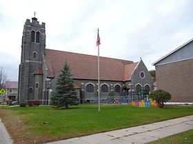
 Église catholique du Saint-Nom-de-Jésus à Au Sable Forks. | ||||
| Administration | ||||
|---|---|---|---|---|
| Pays | ||||
| État | ||||
| Comté | Essex | |||
| Type de localité | Town | |||
| Maire | Matthew J. Stanley | |||
| Code ZIP | 12941 | |||
| Code FIPS | 36-38396 | |||
| GNIS | 0979105 | |||
| Démographie | ||||
| Population | 2 486 hab. () | |||
| Densité | 14 hab./km2 | |||
| Géographie | ||||
| Coordonnées | 44° 23′ 08″ nord, 73° 42′ 38″ ouest | |||
| Altitude | 255 m |
|||
| Superficie | 17 640 ha = 176,4 km2 | |||
| · dont terre | 175,3 km2 (99,38 %) | |||
| · dont eau | 1,1 km2 (0,62 %) | |||
| Fuseau horaire | EST (UTC-5) | |||
| Divers | ||||
| Devise | Home of the Covered Bridge | |||
| Localisation | ||||
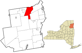
 Carte du comté d'Essex. | ||||
| Géolocalisation sur la carte : États-Unis
Géolocalisation sur la carte : États-Unis
Géolocalisation sur la carte : État de New York
| ||||
| Liens | ||||
| Site web | jaynewyork.com | |||
| modifier |
||||
Jay est une municipalité (town) américaine de l'État de New York, située dans le comté d'Essex.
Géographie
[modifier | modifier le code]La municipalité s'étend sur 176,4 km2 dans le parc Adirondack, au nord du comté d'Essex, à 210 km au nord d'Albany, et est bordée par la rivière Au Sable. Elle abrite la localité centrale de Jay, ainsi que les hameaux d'Au Sable Acres, Au Sable Forks, Green Street, Jersey Section, North Jay, Rome Section, The Grove et Upper Jay.
Histoire
[modifier | modifier le code]La municipalité est créée en 1798 par détachement de la partie ouest de Willsboro et reçoit son nom en l'honneur de John Jay, gouverneur de l'État de New York. Des portions de son territoire sont détachées pour former Keene en 1808, puis Elizabethtown et Wilmington en 1821. Jay est elle-même agrandie en 1822 par le rattachement de territoires détachés de Chateaugay et Peru.
Démographie
[modifier | modifier le code]| Historique des recensements | |||
| Ann. | Pop. | %± | |
|---|---|---|---|
| 1820 | 1 647 | — | |
| 1830 | 1 729 | ▲ +4,98 % | |
| 1840 | 2 258 | ▲ +30,6 % | |
| 1850 | 2 688 | ▲ +19,04 % | |
| 1860 | 2 514 | ▼ −6,47 % | |
| 1870 | 2 496 | ▼ −0,72 % | |
| 1880 | 2 443 | ▼ −2,12 % | |
| 1890 | 1 933 | ▼ −20,88 % | |
| 1900 | 1 744 | ▼ −9,78 % | |
| 1910 | 2 231 | ▲ +27,92 % | |
| 1920 | 2 226 | ▼ −0,22 % | |
| 1930 | 2 153 | ▼ −3,28 % | |
| 1940 | 2 226 | ▲ +3,39 % | |
| 1950 | 2 181 | ▼ −2,02 % | |
| 1960 | 2 257 | ▲ +3,48 % | |
| 1970 | 2 132 | ▼ −5,54 % | |
| 1980 | 2 221 | ▲ +4,17 % | |
| 1990 | 2 244 | ▲ +1,04 % | |
| 2000 | 2 306 | ▲ +2,76 % | |
| 2010 | 2 506 | ▲ +8,67 % | |
| 2020 | 2 486 | ▼ −0,8 % | |
| Recensement décennal des États-Unis[1] | |||
Politique et administration
[modifier | modifier le code]La municipalité est administrée par un superviseur et un conseil de quatre membres élus pour deux ans.
-
Le pont couvert.
Notes et références
[modifier | modifier le code]- (en) « Recensement décennal des États-Unis », Census.gov
Text is available under the CC BY-SA 4.0 license; additional terms may apply.
Images, videos and audio are available under their respective licenses.


