Geitanger
Cet article est une ébauche concernant le monde insulaire et la Norvège.
Vous pouvez partager vos connaissances en l’améliorant (comment ?) selon les recommandations des projets correspondants.
| Geitanger Geitung (no) | |
 Nord de Geitanger | |
| Géographie | |
|---|---|
| Pays | |
| Localisation | Océan Atlantique |
| Coordonnées | 60° 23′ 19″ N, 5° 04′ 33″ E |
| Superficie | 0,89 km2 |
| Point culminant | Søre Nuten (63[1] m) |
| Administration | |
| Région | Vestlandet |
| Comté | Vestland |
| Commune | Øygarden |
| Autres informations | |
| Île en Norvège | |
| modifier |
|


Geitanger ou Geitung, est une île dans le landskap Sunnhordland du comté de Vestland. Elle appartient administrativement à Øygarden.
Géographie
[modifier | modifier le code]Rocheuse et couverte d'arbres, elle s'étend sur environ 1,7 km de longueur pour une largeur approximative de 954 m.
Elle comporte un lac intérieur nommé Vatnet, deux ports abrités de petits cabotages, une route principale sur sa côte ouest et une vingtaine d'habitations. Plusieurs navettes la relie quotidiennement à Knappskog (en), à l'ouest.
Galerie
[modifier | modifier le code]-
 Le port Hamna Keilo
 -
 Départ de la navette
 -
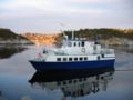 La navette


Notes et références
[modifier | modifier le code]Voir aussi
[modifier | modifier le code]Articles connexes
[modifier | modifier le code]Liens externes
[modifier | modifier le code]- Ressources relatives à la géographie
 :
: - Fiche descriptive
Catégorie
Text is available under the CC BY-SA 4.0 license; additional terms may apply.
Images, videos and audio are available under their respective licenses.
Cover photo is available under {{::mainImage.info.license.name || 'Unknown'}} license.
Cover photo is available under {{::mainImage.info.license.name || 'Unknown'}} license.
Credit:
(see original file).
