Fichier:Nuevo mapa de la Republica Argentina (1914).djvu
Taille de cet aperçu JPG pour ce fichier DJVU : 375 × 599 pixels. Autres résolutions : 150 × 240 pixels | 300 × 480 pixels | 481 × 768 pixels | 641 × 1 024 pixels | 1 282 × 2 048 pixels | 4 719 × 7 535 pixels.
Fichier d’origine (4 719 × 7 535 pixels, taille du fichier : 8,57 Mio, type MIME : image/vnd.djvu)
Ce fichier et sa description proviennent de Wikimedia Commons.
Description
| Description |
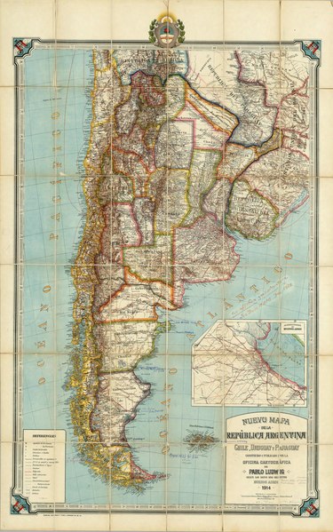
English: New map of the Republic of Argentina, Chile, Uruguay and Paraguay made and published by the Cartographic Office of Pablo Ludwig according to the most recent data. Buenos Aires, 1914, Gunche, Wiebeck and Turtl- O'Brien 121, Bs. As. (with Greater Buenos Aires inset) Español: Nuevo mapa de la Republica Argentina, Chile, Uruguay y Paraguay construido y publicado por la Oficina Cartografica de Pablo Ludwig segun los datos mas recientes. Buenos Aires,1914. Gunche, Wiebeck y Turtl-O'Brien 121, Bs. As. (con Alrededores de Buenos Aires) |
||||
| Date | |||||
| Source | http://www.davidrumsey.com/luna/servlet/detail/RUMSEY~8~1~3701~330005:Nuevo-mapa-de-la-Republica-Argentin | ||||
| Auteur | Pablo Ludwig | ||||
| Autorisation (Réutilisation de ce fichier) |
|
||||
| Autres versions |
|
||||
Historique du fichier
Cliquer sur une date et heure pour voir le fichier tel qu'il était à ce moment-là.
| Date et heure | Vignette | Dimensions | Utilisateur | Commentaire | |
|---|---|---|---|---|---|
| actuel | 16 septembre 2008 à 01:15 |  | 4 719 × 7 535 (8,57 Mio) | Keysanger | ((Information |Description=((es|1=Nuevo mapa de la Republica Argentina, Chile, Uruguay y Paraguay construido y publicado por la Oficina Cartografica de Pablo Ludwig segun los datos mas recientes. Buenos Aires,1914. Gunche, Wiebeck y Turtl-O'Brien 121, Bs. |
Utilisation du fichier
Aucune page n’utilise ce fichier.
Text is available under the CC BY-SA 4.0 license; additional terms may apply.
Images, videos and audio are available under their respective licenses.
Cover photo is available under {{::mainImage.info.license.name || 'Unknown'}} license.
Cover photo is available under {{::mainImage.info.license.name || 'Unknown'}} license.
Credit:
(see original file).
