Fichier:Ethnographic map of hungary 1910 by teleki carte rouge.jpg
Taille de cet aperçu : 800 × 566 pixels. Autres résolutions : 320 × 226 pixels | 640 × 453 pixels | 1 024 × 724 pixels | 1 280 × 905 pixels | 2 560 × 1 810 pixels | 4 962 × 3 509 pixels.
Fichier d’origine (4 962 × 3 509 pixels, taille du fichier : 5,18 Mio, type MIME : image/jpeg)
Ce fichier et sa description proviennent de Wikimedia Commons.
Description
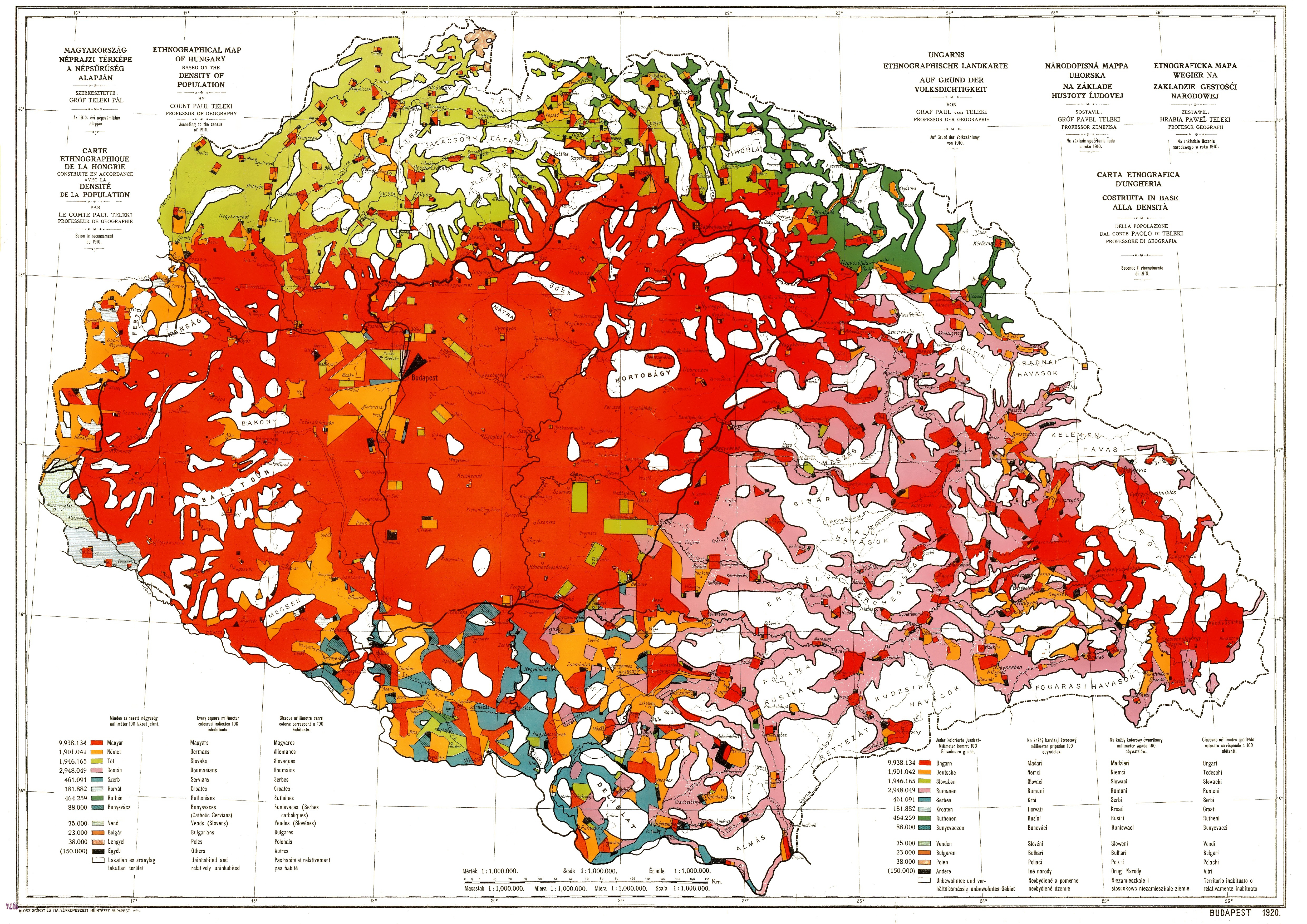
| Description |
English: Ethnographic map of Hungary, based on the density of population according to the census of 1910. Original scale 1 : 1 000 000. Every square millimeter colored indicates 100 inhabitants. "Carte Rouge" - "Red map" was made for the peace talk in Trianon.
Magyar: Magyarország etnikai térképe az 1910-es népszámlálás adatai alapján. Eredeti méretaránya 1 : 1 000 000. Minden négyzetmilliméter 100 lakost jelent. "Carete Rouge" - Vörös Térkép az 1920-as trianoni béketárgyalásokra készült. Teleki Pál 1918-ban Magyarország néprajzi térképe a népsűrűség alapján című műve szerkesztésénél egy módszertani újdonsággal jelentkezett. Az 1910-es népszámlálás alapján szerkesztett 1:1 milliós térképén arra törekedett, hogy a nemzetiség számaránya és a lakott területük aránya közötti viszonyt megjelenítse, hogy így a népsűrűség is kitűnjék a lakatlanul maradt terület nagyságából. Térképén minden járás területéből csak annyi mm2 térképi felületet töltött ki az ott élő nemzetiségek színével, ahány száz fő élt ott. Tehát térképén minden mm2 száz lakost jelent. Ahol a népsűrűség nem érte el a száz főt, ott bizonyos nagyságú terület fehéren, azaz lakatlanul maradt. Így jól kitűnik például a hegyvidékek ritka lakossága. Viszont ahol meghaladja a száz fő/km2 értéket a népsűrűség, például a városokban, ott a lakosságszám nem fér bele a település térképi vonatkozási felületébe. Teleki ezt a problémát úgy oldotta meg, hogy a népesség számát mértani idomokba rendezve helyezte el a város körül, azaz nem mindenütt jelenik meg a lakosság pontosan azon a területen, ahol a valóságban él. Mivel nem pontos helyén van minden nemzetiséget jelölő színfolt, ezért inkább csak kartogramnak tekinthetjük a művet. Néprajzi határok kijelölésére tehát nem alkalmas, de az ország vagy egyes részei igazságos és valóságos nemzetiségi térképének megítélésére nagyszerűen megfelel, mert egyetlen nemzetiség sem kapott arányán felüli vagy aluli színfoltot. A munka, amely tizenkét színnel jeleníti meg a nemzetiségek képét, számos kiadást ért meg. Megjelent magyar, német, francia és angol szöveggel is, és ez volt az egyetlen térkép, amelyet az 1920-as párizsi béketárgyaláson megtekintettek. Ott kapta a nevét is a magyar nemzetiséget jelölő színről: Carte rouge. |
|||||||||||||||||||||||
| Date | ||||||||||||||||||||||||
| Source | Scanned from an original | |||||||||||||||||||||||
| Auteur |
|
|||||||||||||||||||||||

Conditions d’utilisation
|
Cette œuvre est également dans le domaine public dans tous les pays pour lesquels le droit d’auteur a une durée de vie de 70 ans ou moins après la mort de l’auteur. | |
| Ce fichier a été identifié comme étant exempt de restrictions connues liées au droit d’auteur, y compris tous les droits connexes et voisins. | |
Historique du fichier
Cliquer sur une date et heure pour voir le fichier tel qu'il était à ce moment-là.
| Date et heure | Vignette | Dimensions | Utilisateur | Commentaire | |
|---|---|---|---|---|---|
| actuel | 22 janvier 2016 à 18:46 | | 4 962 × 3 509 (5,18 Mio) | Qorilla | removed some noise, dots, smears |
| 28 décembre 2009 à 20:32 |  | 4 962 × 3 509 (4,6 Mio) | Qorilla | whitening and other improvements | |
| 2 décembre 2009 à 15:57 |  | 4 962 × 3 509 (3,11 Mio) | Bercess | ((Information |Description=((en|1=Ethnographic map of Hungary, based on the density of population according to the census of 1910. Original scale 1 : 1 000 000. Every square millimeter colored indicates 100 inhabitants. "Carte Rouge" - "Red map" was made |
Utilisation du fichier
Les 5 pages suivantes utilisent ce fichier :
Usage global du fichier
Les autres wikis suivants utilisent ce fichier :
- Utilisation sur ast.wikipedia.org
- Utilisation sur azb.wikipedia.org
- Utilisation sur bn.wikipedia.org
- Utilisation sur ca.wikipedia.org
- Utilisation sur cs.wikipedia.org
- Utilisation sur cy.wikipedia.org
- Utilisation sur de.wikipedia.org
- Utilisation sur el.wikipedia.org
- Utilisation sur en.wikipedia.org
- Utilisation sur es.wikipedia.org
- Utilisation sur et.wikipedia.org
- Utilisation sur fa.wikipedia.org
- Utilisation sur fi.wikipedia.org
- Utilisation sur hr.wikipedia.org
- Utilisation sur hu.wikipedia.org
- Utilisation sur id.wikipedia.org
- Utilisation sur ko.wikipedia.org
- Utilisation sur la.wikipedia.org
- Utilisation sur pl.wikipedia.org
- Utilisation sur sl.wikipedia.org
- Utilisation sur sr.wikipedia.org
- Utilisation sur tr.wikipedia.org
- Utilisation sur uk.wikipedia.org
- Utilisation sur www.wikidata.org
Métadonnées
Text is available under the CC BY-SA 4.0 license; additional terms may apply.
Images, videos and audio are available under their respective licenses.
Cover photo is available under {{::mainImage.info.license.name || 'Unknown'}} license.
Cover photo is available under {{::mainImage.info.license.name || 'Unknown'}} license.
Credit:
(see original file).
