District Sud (Séville)
| District Sud | ||||
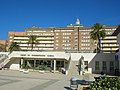
 La place d'Espagne, place emblématique du district Sud. | ||||
| Administration | ||||
|---|---|---|---|---|
| Pays | ||||
| Ville | Séville | |||
| Démographie | ||||
| Population | 75 620 hab. | |||
| Fonctions urbaines | Logements, industries | |||
| Géographie | ||||
| Coordonnées | 37° 22′ 05″ nord, 5° 58′ 13″ ouest | |||
| Altitude | 10 m |
|||
| Cours d’eau | Canal Alphonse-XIII | |||
| Transport | ||||
| Bus | plusieurs lignes de Tussam | |||
| Localisation | ||||
 Localisation du district Sud dans la ville de Séville | ||||
| Géolocalisation sur la carte : Séville
Géolocalisation sur la carte : Andalousie
Géolocalisation sur la carte : Espagne
| ||||
| modifier |
||||


Le district Sud (distrito Sur en espagnol) est un des onze districts administratifs de la ville andalouse de Séville, en Espagne[1].
Il est situé au centre sud de la ville. Il est limité au sud par le district de Bellavista–La Palmera, à l'ouest par le canal Alphonse-XIII et par le district de Los Remedios, au nord-ouest par le district Casco Antiguo, au nord-est par les districts de Nervión et de Cerro-Amate et par la commune d'Alcalá de Guadaíra et à l'est par la commune de Dos Hermanas. Sa population est de 75 620 habitants[2].
Quartiers
[modifier | modifier le code]Le district est formé de 14 quartiers[2] :
- Prado - Parque de María Luisa (846 habitants)
- Huerta de la Salud (5 120 habitants)
- El Porvenir (6 959 habitants)
- Tabladilla, la Estrella (3 906 habitants)
- Bami (4 035 habitants)
- Giralda Sur (2 392 habitants)
- El Plantinar (6 833 habitants)
- Felipe II, Los Diez Mandamientos (2 854 habitants)
- Tiro de Linea, Santa Genoveva (5 200 habitants)
- El Juncal, Hispalis (5 961 habitants)
- La Oliva (5 943 habitants)
- Avenida de la Paz (3 528 habitants)
- Las Letanías (4 106 habitants)
- Polígono Sur (17 937 habitants)
-
 La place d'Amérique se trouve dans le district Sud.
 -
 Le district possède le parc de María Luisa, le plus grand parc de la ville.
 -
 Les Hôpitaux universitaires Virgen del Rocío se trouvent sur le territoire du district.


Références
[modifier | modifier le code]- (es) « Distritos Municipales », sur sevilla.org (consulté le ).
- (es) « Datos censales y demográficos »(Archive.org • Wikiwix • Archive.is • Google • Que faire ?), sur sevilla.org (consulté le ).
Text is available under the CC BY-SA 4.0 license; additional terms may apply.
Images, videos and audio are available under their respective licenses.
Cover photo is available under {{::mainImage.info.license.name || 'Unknown'}} license.
Cover photo is available under {{::mainImage.info.license.name || 'Unknown'}} license.
Credit:
(see original file).
