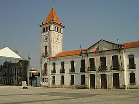
Cantanhede (Portugal)
| Cantanhede | |
 Héraldique |
|
 Cantanhede | |
| Administration | |
|---|---|
| Pays | |
| Région | Centre |
| Sous-région | Bas Mondego |
| Ancienne province | Beira littorale |
| District | Coimbra |
| Démographie | |
| Population | 36 595 hab. (2011[1]) |
| Densité | 93 hab./km2 |
| Géographie | |
| Coordonnées | 40° 21′ nord, 8° 36′ ouest |
| Superficie | 39 218 ha = 392,18 km2 |
| Localisation | |
| Liens | |
| Site web | http://www.cm-cantanhede.pt |
| modifier |
|
Cantanhede est une municipalité (en portugais : concelho ou município) du Portugal, située dans le district de Coimbra et la région Centre.
Géographie
[modifier | modifier le code]Cantanhede est limitrophe :
- au nord, de Vagos, d'Oliveira do Bairro et d'Anadia,
- à l'est, de Mealhada,
- au sud-est, de Coimbra,
- au sud, de Montemor-o-Velho et de Figueira da Foz,
- au nord-ouest, de Mira.
La municipalité dispose en outre d'un façade maritime, à l'ouest, sur l'océan Atlantique.
Économie
[modifier | modifier le code]Cantanhede est un gros bourg agricole et un centre de commerce du vin, des céréales et du bois.
Entre Cantanhede et Ança (10 km au sud-est), on extrait le fameux calcaire blanc connu sous le nom de pierre d'Ança. Aussi facile à travailler que le bois, elle fut très appréciée par les architectes et les sculpteurs de la région, principalement par ceux de l'école de Coimbra.
Une base logistique du Groupement Les Mousquetaires (Intermarché, Netto...) est implanté sur le territoire de la ville de Cantanhede.
Démographie
[modifier | modifier le code]Jumelages
[modifier | modifier le code] Alfortville (France) depuis 2000
Subdivisions
[modifier | modifier le code]La municipalité de Cantanhede groupe 19 paroisses (freguesia, en portugais) :
- Ançã
- Bolho
- Cadima
- Camarneira
- Cantanhede : a rang de « cité »
- Cordinhã
- Corticeiro de Cima
- Covões
- Febres
- Murtede
- Ourentã
- Outil
- Pocariça
- Portunhos
- Sanguinheira
- São Caetano
- Sepins
- Tocha
- Vilamar
Personnalités
[modifier | modifier le code]- Squeeze Theeze Pleeze, groupe de pop-rock alternatif originaire de Cantanhede.
Liens externes
[modifier | modifier le code]
- Site officiel
- Ressource relative à la musique :
- Site du Concelho de Cantanhede
Notes et références
[modifier | modifier le code]- (pt)INE, « Résultats définitifs du recensement 2011 », (consulté le )
Text is available under the CC BY-SA 4.0 license; additional terms may apply.
Images, videos and audio are available under their respective licenses.


