Šarengrad
| Šarengrad | |
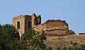
 Vue de Šarengrad, avec les ruines de la forteresse | |
| Administration | |
|---|---|
| Pays | |
| Comitat | |
| Municipalité | Ilok |
| Code postal | 32234 Šarengrad |
| Indicatif téléphonique international | +(385) |
| Indicatif téléphonique local | 0 32 |
| Démographie | |
| Population | 528 hab. (2011[1]) |
| Densité | 16 hab./km2 |
| Géographie | |
| Coordonnées | 45° 13′ 59″ nord, 19° 16′ 48″ est |
| Altitude | 92 m |
| Superficie | 3 330 ha = 33,3 km2 |
| Localisation | |
| Liens | |
| Site web | www.inet.hr/~dsarace/ |
| modifier |
|


Šarengrad (en serbe en écriture cyrillique : Шаренград, en hongrois : Atya, en allemand : Wetterwardein) est une localité de l'est de la Croatie située dans la municipalité d'Ilok, comitat de Vukovar-Syrmie. Elle est située le long du Danube. Šarengrad est connu pour son paysage dominé par la rivière, les maisons pittoresques et le clocher de l'église qui la borde. L'île de Šarengrad (en) est une île fluviale de 9 km² située à proximité du village.
Géographie
[modifier | modifier le code]Le village se situe dans la région de Syrmie, sur les pentes de Fruška gora, près du Danube.
Démographie
[modifier | modifier le code]Selon le recensement de 2011, Šarengrad comptait 528 habitants[2].
| Population[3] | |||||||||||||||
|---|---|---|---|---|---|---|---|---|---|---|---|---|---|---|---|
| 1857 | 1869 | 1880 | 1890 | 1900 | 1910 | 1921 | 1931 | 1948 | 1953 | 1961 | 1971 | 1981 | 1991 | 2001 | 2011 |
| 1 265 | 1 484 | 1 424 | 1 558 | 1 489 | 1 472 | 1 392 | 1 448 | 1 349 | 1 622 | 1 443 | 1 357 | 1 106 | 1 005 | 838 | 528 |
Recensement de 1991
[modifier | modifier le code]| Šarengrad[4] |
|---|
| 1991 |
Total : 1 005
|

Recensement de 1910
[modifier | modifier le code]| Šarengrad[4] | |
|---|---|
| Population par langue | Population par religion |
Total : 1 472
| |
Galerie
[modifier | modifier le code]-

-

-
 Château médiéval
 -
 Cimetière des Partisans yougoslaves

.JPG)

Notes et références
[modifier | modifier le code]- (en) Cet article est partiellement ou en totalité issu de l’article de Wikipédia en anglais intitulé « Šarengrad » (voir la liste des auteurs).
- « Vukovar-Srijem County - Town of Ilok », State Statistics Bureau of the Republic of Croatia, (consulté le )
- « Državni zavod za statistiku Republike Hrvatske »
- - Republika Hrvatska - Državni zavod za statistiku: Naselja i stanovništvo Republike Hrvatske 1857.-2001.
- Book: "Ethnic and religious composition of population of Croatia, 1880-1991: by settlements", author: Jakov Gelo, publisher: Zagreb, Croatian bureau of statistics, 1998., (ISBN 953-6667-07-X), (ISBN 978-953-6667-07-9);
Voir aussi
[modifier | modifier le code]Articles connexes
[modifier | modifier le code]Lien externe
[modifier | modifier le code]- (hr) Site
Text is available under the CC BY-SA 4.0 license; additional terms may apply.
Images, videos and audio are available under their respective licenses.
Cover photo is available under {{::mainImage.info.license.name || 'Unknown'}} license.
Cover photo is available under {{::mainImage.info.license.name || 'Unknown'}} license.
Credit:
(see original file).
