Providence
| Providence, Rhode Island | ||
|---|---|---|
| Býur | ||
| City of Providence | ||
 Frá ovast vinstrumegin: Umhvarvið av Downtown Providence og Providence-áin frá Point Street Bridge, Federal Hill, University Hall í Brown University, Roger Williams Park, tann fyrsta Baptistakirkjan í USA, WaterFire í Waterplace Park, og Rhode Island State House. | ||
| ||
| Kelinavn: The Creative Capital, Beehive of Industry, the Renaissance City, the Divine City | ||
| Motto: What cheer? | ||
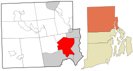
 Staðseting í Providence County og lutstatinum Rhode Island. | ||
| Coordinates: 41°49′25″N 71°25′20″W / 41.82361°N 71.42222°WCoordinates: 41°49′25″N 71°25′20″W / 41.82361°N 71.42222°W | ||
| Land | USA | |
| Lutstatur | Rhode Island | |
| County | Providence | |
| Stjórn | ||
| • Slag | Providence Býráð | |
| • Borgarstjóri | Brett P. Smiley (D) | |
| Øki | ||
| • Býur | [[1 E+Feilur í frágreiðing: Ókend teknseting "["._m²|Bad rounding here66 km2]] (25,5 sq mi) | |
| • Land | Bad rounding here48 km2 (18,5 sq mi) | |
| • Vatn | Bad rounding here5,4 km2 (2,1 sq mi) | |
| Hædd | 23 m (75 ft) | |
| Fólkatal (2010)[1] | ||
| • Býur | 178.042 | |
| • Meting (2013)[2] | 177.994 | |
| • Støða | USA: 134. | |
| • Tættleiki | Bad rounding here3,700/km2 (9,676,2/sq mi) | |
| • Býarøki | 1,190,956 (USA: 39,) | |
| • Stórbýur | 1,604,291 (USA: 38th) | |
| Tíðasona | EST (UTC-5) | |
| • Summar (DST) | EDT (UTC-4) | |
| ZIP kota | 02901–02912, 02918, 02919, 02940 | |
| Økiskota | 401 | |
| FIPS kota | 44-59000[3] | |
| GNIS feature ID | 1219851[4] | |
| Heimasíða | www.providenceri.com | |
Providence er høvuðsstaður og størsti býur í Rhode Island.
Keldur
[rætta | rætta wikitekst]- ↑ "American FactFinder". United States Census Bureau. http://factfinder2.census.gov/faces/nav/jsf/pages/index.xhtml. Heintað March 15, 2015.
- ↑ "Population Estimates". United States Census Bureau. http://www.census.gov/popest/data/cities/totals/2013/SUB-EST2013-3.html. Heintað March 15, 2015.
- ↑ "American FactFinder". United States Census Bureau. http://factfinder2.census.gov. Heintað 2008-01-31.
- ↑ "US Board on Geographic Names". United States Geological Survey. 2007-10-25. http://geonames.usgs.gov. Heintað 2008-01-31.
Text is available under the CC BY-SA 4.0 license; additional terms may apply.
Images, videos and audio are available under their respective licenses.

