For faster navigation, this Iframe is preloading the Wikiwand page for Tiedosto:Zuid-Holland position.svg.

Tiedosto:Zuid-Holland position.svg

Wikipediasta
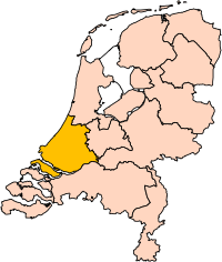
Alkuperäinen tiedosto(SVG-tiedosto; oletustarkkuus 200 × 236 kuvapistettä; tiedostokoko 158 KiB)

Yhteenveto

Kuvaus Location of the province of South-Holland (South Holland) in the Netherlands.
Päiväys
Lähde Own work, based on freely available GIS data
Tekijä User:Mtcv
Käyttöoikeus
(Tämän tiedoston uudelleenkäyttö)
Data: attribution required; my work: PD
Muut versiot I attempted to make an svg version of Image:Zuid Holland-Position.png (with less simplified boundaries)

Clickable version

South HollandNorth HollandFrieslandGroningenDrentheFlevolandOverijsselGelderlandUtrechtLimburgNorth BrabantZeeland

Lisenssi

© Tämän teoksen tekijänoikeuksien haltija, Centraal Bureau voor de Statistiek, sallii kenen tahansa käyttää sitä mihin tahansa tarkoitukseen, edellyttäen että tekijänoikeuksien haltija on asianmukaisesti mainittu. Teoksen uudelleen käyttö, muokkaaminen, kaupallinen käyttö ja muu käyttö on sallittu.

VRT Wikimedia

Tämän teoksen käyttölupa on hyväksytty ja arkistoitu Wikimedia Foundationin VRT-järjestelmään. Voit lukea sen tikettinä #2007041210008226 jos sinulla on VRTS-tili. Jos olet Commonsin normaali käyttäjä ja haluat kysyä jostakin luvasta tai varmistua luvan oikeellisuudesta, ole hyvä ja ota yhteyttä VRT-vapaaehtoiseen tai jätä viesti VRT-ilmoitustaululle. Jos haluat käyttää tätä teosta jossain muualla, ole hyvä ja lue ohjeet täällä.

Linkki tikettiin: https://ticket.wikimedia.org/otrs/index.pl?Action=AgentTicketZoom&TicketNumber=2007041210008226
Find other files from the same ticket: SDC query (SPARQL)

This image is (in part or entirely) based on geographical data from Statistics Netherlands (Centraal Bureau voor de Statistiek). Digital geometry files in ESRI format can be downloaded from their website [1].

In particular, boundary data of statistical districts is based on either the Wijk- en buurtkaart 2005, or the Wijk- en buurtkaart 2003 ("CBS/TOPgrenzen"). Data on localities (bevolkingskernen) are from the publication Bevolkingskernen in Nederland 2001.

Conditions of use (in Dutch):

  • Bij visualisering van gegevens met behulp van het digitale bestand Wijk- en buurtkaart 2005 dient te worden vermeld:
Bron: © 2006, Centraal Bureau voor de Statistiek / Topografische Dienst Kadaster
  • Bij visualisering van gegevens met behulp van het digitale bestand CBS/TOPgrenzen dient te worden vermeld:
Grenzen ondergrond: © 2003, Centraal Bureau voor de Statistiek/Topografische Dienst Kadaster
  • Bij visualisering van gegevens met behulp van het digitale bestand "Bevolkingskernen 2001" dient te worden vermeld:
Bron: © 2005, Centraal Bureau voor de Statistiek

Unless otherwise specified, data on waterways and lakes are from the public domain Digital Chart of the World.

Annotations
InfoField
This image is annotated: View the annotations at Commons

Kuvatekstit

Lisää yhden rivin pituinen kuvaus tästä tiedostosta

Kohteet, joita tässä tiedostossa esitetään

esittää

3. lokakuu 2006

Tiedoston historia

Päiväystä napsauttamalla näet, millainen tiedosto oli kyseisellä hetkellä.

PäiväysPienoiskuvaKokoKäyttäjäKommentti
nykyinen2. maaliskuuta 2019 kello 20.21Pienoiskuva 2. maaliskuuta 2019 kello 20.21 tallennetusta versiosta200 × 236 (158 KiB)Thaytsupdate
3. lokakuuta 2006 kello 03.49Pienoiskuva 3. lokakuuta 2006 kello 03.49 tallennetusta versiosta200 × 236 (158 KiB)Mtcv((Information| |Description=Location of the province of Noord-Holland (North Holland) in the Netherlands. |Source=Own work, based on freely available GIS data |Date=2006-10-03 |Author=User:Mtcv |Permission=Data: attribution required; my work: PD |othe

Tiedoston käyttö

Tiedoston järjestelmänlaajuinen käyttö

Metatieto

{{bottomLinkPreText}} {{bottomLinkText}}
Tiedosto:Zuid-Holland position.svg
Listen to this article

This browser is not supported by Wikiwand :(
Wikiwand requires a browser with modern capabilities in order to provide you with the best reading experience.
Please download and use one of the following browsers:

This article was just edited, click to reload
This article has been deleted on Wikipedia (Why?)

Back to homepage

Please click Add in the dialog above
Please click Allow in the top-left corner,
then click Install Now in the dialog
Please click Open in the download dialog,
then click Install
Please click the "Downloads" icon in the Safari toolbar, open the first download in the list,
then click Install
{{::$root.activation.text}}

Install Wikiwand

Install on Chrome Install on Firefox
Don't forget to rate us

Tell your friends about Wikiwand!

Gmail Facebook Twitter Link

Enjoying Wikiwand?

Tell your friends and spread the love:
Share on Gmail Share on Facebook Share on Twitter Share on Buffer

Our magic isn't perfect

You can help our automatic cover photo selection by reporting an unsuitable photo.

This photo is visually disturbing This photo is not a good choice

Thank you for helping!


Your input will affect cover photo selection, along with input from other users.

X

Get ready for Wikiwand 2.0 🎉! the new version arrives on September 1st! Don't want to wait?