Tiedosto:Kiplingseastcoast2.JPG
Wikipediasta
Tarkempaa kuvaa ei ole saatavilla.
Kiplingseastcoast2.JPG (501 × 574 kuvapistettä, 114 KiB, MIME-tyyppi: image/jpeg)
| Tämä tiedosto on tiedostotietokanta Wikimedia Commonsista. Tiedot kuvaussivulta näkyvät alla. |  |
Tiedoston kuvaussivu Commonsissa |
Yhteenveto
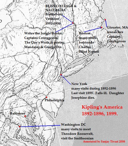
| Kuvaus | This is a reduced, cropped and version of a physical map of the United States which is in the public domain([1]), and downloaded from the University of Texas website: [2]The map was then annotated by me (Sanjay Tiwari 02:42, 13 October 2006 (UTC)) and is now being released to the public domain. |
| Päiväys | 13. lokakuuta 2006 (alkuperäinen tallennuspäivä) |
| Lähde | Siirretty projektista en.wikipedia Commonsiin. |
| Tekijä | Sanjay Tiwari projektissa Wikipedia kielellä englanti |
Lisenssi
| Minä, tämän teoksen tekijänoikeudellinen omistaja, julkaisen tämän teoksen public domainiin eli luovun kaikista tekijänoikeuksista lain sallimissa puitteissa. Tämä on voimassa maailmanlaajuisesti. Joissain maissa laki ei mahdollista tätä. Mikäli näin on: Myönnän kenelle tahansa oikeuden käyttää tätä teosta mihin tahansa tarkoitukseen, ilman mitään ehtoja, ellei laki vaadi ehtojen asettamista. |
Alkuperäinen tallennusloki
Alkuperäinen kuvaussivu oli täällä. Käyttäjätunnukset alla viittaavat kohteeseen en.wikipedia.
- 2006-10-13 02:42 Sanjay Tiwari 501×574×8 (116822 bytes) This is a reduced, cropped and version of a physical map of the United States which is in the public domain([http://www.lib.utexas.edu/maps/faq.html]), and downloaded from the University of Texas website: [http://www.lib.utexas.edu/maps/national_atlas_197
Lisenssi
|
Tämä teos on public domainissa lähes maailmanlaajuisesti, koska tekijän kuolemasta on kulunut yli 70 vuotta. | |
| Tämä teos on vapaa tunnetuista tekijänoikeuslain mukaisista rajoituksista, mukaanlukien lähioikeuksista. | |
Tiedoston historia
Päiväystä napsauttamalla näet, millainen tiedosto oli kyseisellä hetkellä.
| Päiväys | Pienoiskuva | Koko | Käyttäjä | Kommentti | |
|---|---|---|---|---|---|
| nykyinen | 18. marraskuuta 2006 kello 02.11 | | 501 × 574 (114 KiB) | Chechof | ((Information |Description=This is a reduced, cropped and version of a physical map of the United States which is in the public domain([http://www.lib.utexas.edu/maps/faq.html]), and downloaded from the University of Texas website: [http://www.lib.utexas. |
Tiedoston käyttö
Seuraava sivu käyttää tätä tiedostoa:
Tiedoston järjestelmänlaajuinen käyttö
Seuraavat muut wikit käyttävät tätä tiedostoa:
- Käyttö sivustolla ca.wikipedia.org
- Käyttö sivustolla en.wikipedia.org
- Käyttö sivustolla es.wikipedia.org
- Käyttö sivustolla eu.wikipedia.org
- Käyttö sivustolla fr.wikipedia.org
- Käyttö sivustolla gl.wikipedia.org
- Käyttö sivustolla hi.wikipedia.org
- Käyttö sivustolla ht.wikipedia.org
- Käyttö sivustolla hu.wikipedia.org
- Käyttö sivustolla ja.wikipedia.org
- Käyttö sivustolla lt.wikipedia.org
Metatieto
Text is available under the CC BY-SA 4.0 license; additional terms may apply.
Images, videos and audio are available under their respective licenses.
Cover photo is available under {{::mainImage.info.license.name || 'Unknown'}} license.
Cover photo is available under {{::mainImage.info.license.name || 'Unknown'}} license.
Credit:
(see original file).
