Tiedosto:Dioecesis Thraciae 400 AD.png
Wikipediasta
Tarkempaa kuvaa ei ole saatavilla.
Dioecesis_Thraciae_400_AD.png (461 × 352 kuvapistettä, 205 KiB, MIME-tyyppi: image/png)
| Tämä tiedosto on tiedostotietokanta Wikimedia Commonsista. Tiedot kuvaussivulta näkyvät alla. |  |
Tiedoston kuvaussivu Commonsissa |
Yhteenveto
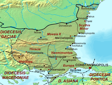
| Kuvaus | Map of the Diocese of Thrace (Dioecesis Thraciae) ca. 400 AD, showing the subordinate provinces and the major cities. |
| Päiväys | |
| Lähde |
Base map found at en:Topographic map#Global 1-kilometer map, otherwise self-made. Data based on maps in atlases and the internet and on contemporary sources, primarily the Notitia Dignitatum. Note: The exact course of the provincial boundaries is very uncertain and in many cases only approximate. |
| Tekijä | Cplakidas |
Lisenssi
| Minä, tämän teoksen tekijänoikeudellinen omistaja, julkaisen tämän teoksen public domainiin eli luovun kaikista tekijänoikeuksista lain sallimissa puitteissa. Tämä on voimassa maailmanlaajuisesti. Joissain maissa laki ei mahdollista tätä. Mikäli näin on: Myönnän kenelle tahansa oikeuden käyttää tätä teosta mihin tahansa tarkoitukseen, ilman mitään ehtoja, ellei laki vaadi ehtojen asettamista. |
Tiedoston historia
Päiväystä napsauttamalla näet, millainen tiedosto oli kyseisellä hetkellä.
| Päiväys | Pienoiskuva | Koko | Käyttäjä | Kommentti | |
|---|---|---|---|---|---|
| nykyinen | 20. toukokuuta 2017 kello 17.30 | | 461 × 352 (205 KiB) | Julieta39 | Antic shoreline of the Danube mouths since Grigore Antipa's "Black Sea" (1940) and Andrei Nacu's paleomap [https://fr.wikipedia.org/wiki/Delta_du_Danube#/media/File:Danube_Delta_evolution.gif]. |
| 2. lokakuuta 2007 kello 19.25 |  | 461 × 352 (139 KiB) | Cplakidas | ((Information |Description=Map of the Diocese of Thrace (''Dioecesis Thraciae'') ca. 400 AD, showing the subordinate provinces and the major cities. |Source=Base map found at en:Topographic map#Global 1-kilometer map, other |
Tiedoston käyttö
Seuraava sivu käyttää tätä tiedostoa:
Tiedoston järjestelmänlaajuinen käyttö
Seuraavat muut wikit käyttävät tätä tiedostoa:
- Käyttö sivustolla an.wikipedia.org
- Käyttö sivustolla ar.wikipedia.org
- Käyttö sivustolla arz.wikipedia.org
- Käyttö sivustolla az.wikipedia.org
- Käyttö sivustolla be.wikipedia.org
- Käyttö sivustolla bg.wikipedia.org
- Käyttö sivustolla ca.wikipedia.org
- Käyttö sivustolla cs.wikipedia.org
- Käyttö sivustolla da.wikipedia.org
- Käyttö sivustolla de.wikipedia.org
- Käyttö sivustolla de.wikivoyage.org
- Käyttö sivustolla el.wikipedia.org
- Käyttö sivustolla en.wikipedia.org
- Käyttö sivustolla es.wikipedia.org
Näytä lisää tämän tiedoston järjestelmänlaajuista käyttöä.
Metatieto
Text is available under the CC BY-SA 4.0 license; additional terms may apply.
Images, videos and audio are available under their respective licenses.
Cover photo is available under {{::mainImage.info.license.name || 'Unknown'}} license.
Cover photo is available under {{::mainImage.info.license.name || 'Unknown'}} license.
Credit:
(see original file).
