پرونده:Makurazaki in Kagoshima Prefecture.png
اندازهٔ این پیشنمایش: ۸۰۰ × ۵۳۴ پیکسل. کیفیتهای دیگر: ۳۲۰ × ۲۱۳ پیکسل | ۶۴۰ × ۴۲۷ پیکسل | ۱٬۰۲۴ × ۶۸۳ پیکسل | ۱٬۲۰۱ × ۸۰۱ پیکسل.
پروندهٔ اصلی (۱٬۲۰۱ × ۸۰۱ پیکسل، اندازهٔ پرونده: ۳۴ کیلوبایت، نوع MIME پرونده: image/png)
این پرونده در ویکیانبار موجود است. محتویات صفحهٔ توصیف آن در زیر نمایش داده میشود. |
خلاصه
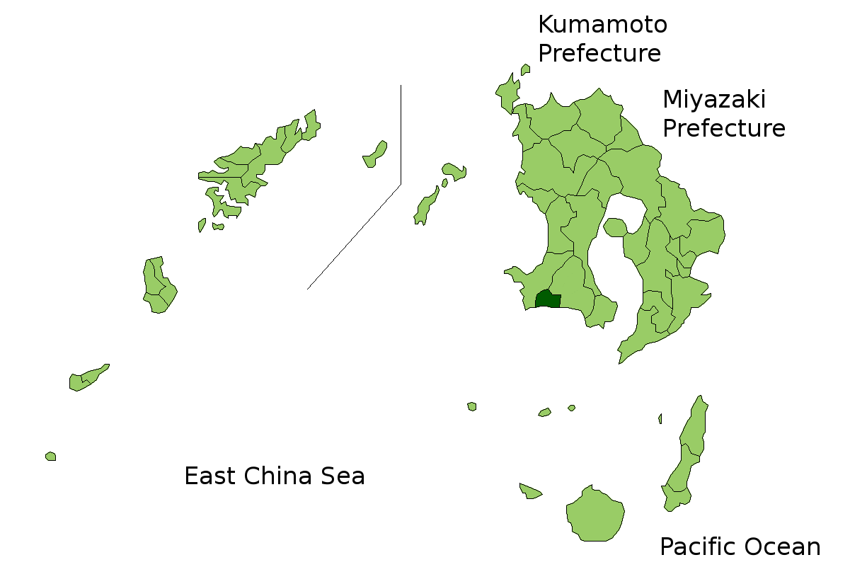
| توضیح | Location Map of Makurazaki in Kagoshima Prefecture, Japan |
| تاریخ | |
| منبع | Image:KagoshimaMapCurrent.png and rework |
| پدیدآور | user:alberth2 |
| اجازهنامه (استفادهٔ مجدد از این پرونده) |
PD |
اجازهنامه
| من، دارنده حق تکثیر این اثر، این اثر را به مالکیت عمومی منتشر میکنم. این قابل اجرا در تمام نقاط جهان است. در برخی از کشورها ممکن است به صورت قانونی این امکانپذیر نباشد؛ اگر چنین است: من اجازهٔ استفاده از این اثر را برای هر مقصودی، بدون هیچگونه شرایطی میدهم، تا وقتی که این شرایط توسط قانون مستلزم نشده باشد. |
تاریخچهٔ پرونده
روی تاریخ/زمانها کلیک کنید تا نسخهٔ مربوط به آن هنگام را ببینید.
| تاریخ/زمان | بندانگشتی | ابعاد | کاربر | توضیح | |
|---|---|---|---|---|---|
| کنونی | ۲۳ مارس ۲۰۱۰، ساعت ۰۶:۴۳ | | ۱٬۲۰۱ در ۸۰۱ (۳۴ کیلوبایت) | Alberth2 | Kajiki Town, Kamō Town and Aira Tow were merged to Aira City. |
| ۱ نوامبر ۲۰۰۸، ساعت ۰۳:۰۹ |  | ۱٬۲۰۱ در ۸۰۱ (۳۴ کیلوبایت) | Alberth2 | Ōkuchi and Hishikari merged to Isa. | |
| ۱ دسامبر ۲۰۰۷، ساعت ۰۶:۲۷ |  | ۱٬۲۰۱ در ۸۰۱ (۳۴ کیلوبایت) | Alberth2 | Kawanabe, Chiran, and Ei are merged into Minamikyūshū City. | |
| ۵ اکتبر ۲۰۰۷، ساعت ۰۱:۲۰ |  | ۱٬۲۰۱ در ۸۰۱ (۳۴ کیلوبایت) | Alberth2 | == Summary == ((Information |Description=Location Map of Makurazaki in Kagoshima Prefecture, Japan |Source=Image:KagoshimaMapCurrent.png and rework |Date=Oct. 5th, 2007 |Author=user:alberth2 |Permission=PD |other_versions= )) == Licensing == ((P |
کاربرد پرونده
صفحهٔ زیر از این تصویر استفاده میکند:
کاربرد سراسری پرونده
ویکیهای دیگر زیر از این پرونده استفاده میکنند:
- کاربرد در it.wikipedia.org
- کاربرد در ro.wikipedia.org
- کاربرد در tg.wikipedia.org
- کاربرد در vi.wikipedia.org
- کاربرد در zh-classical.wikipedia.org
- کاربرد در zh.wikipedia.org
Text is available under the CC BY-SA 4.0 license; additional terms may apply.
Images, videos and audio are available under their respective licenses.
Cover photo is available under {{::mainImage.info.license.name || 'Unknown'}} license.
Cover photo is available under {{::mainImage.info.license.name || 'Unknown'}} license.
Credit:
(see original file).
