سومالیلند
جمهوری سومالیلند Jamhuuriyadda Soomaaliland جمهوریة صومالیلاند | |
|---|---|
شعار: لا إله إلا الله محمد رسولالله | |
سرود: "Samo ku waar" حیاه طویلة مع السلامLong life with peace | |
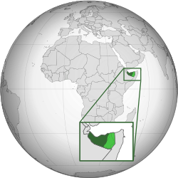
 سومالیلند (سبز پر رنگ) مناقشه ارضی (سبز روشن) | |
| وضعیت | کشوری با رسمیت محدود؛ توسط سازمان ملل متحد به عنوان بخشی از سومالی به رسمیت شناخته شده است |
| پایتخت و بزرگترین شهر | هرجیسا ۹°۳۳′ شمالی ۴۴°۰۳′ شرقی / ۹٫۵۵۰°شمالی ۴۴٫۰۵۰°شرقی |
| زبان(های) رسمی | سومالیایی |
| دین(ها) | اسلام (رسمی) |
| حکومت | |
| موسی بیهی عبدی عبد الرحمن اسماعیل زیلعی | |
| بنیانگذاری | ۱۸ مه ۱۹۹۱ |
| مساحت | |
• کل | ۱۷۶٬۱۲۰ کیلومتر مربع (۶۸٬۰۰۰ مایل مربع) (-ام) |
• آبها (٪) | - |
| جمعیت | |
• سرشماری | ۵٬۷۴۱٬۰۸۶ (-ام) |
| واحد پول | شیلینگ سومالیلند (ندارد) |
| منطقه زمانی | EAT |
• تابستان (ساعت تابستانی) | DAS |
| پیششماره تلفنی | ۲۵۲+ |
| دامنه سطحبالا | ندارد |

سومالیلند (به سومالیایی: Soomaaliland؛ به عربی: صومالیلاند) با نام رسمی جمهوری سومالیلند، نامی است که قبایل پنج استان شمالی سومالی از ۱۹۹۱ به خود داده و از کشور سومالی اعلام استقلال کردهاند. پایتخت سومالیلند، هرجیسا است. هنوز هیچ کشوری، سومالیلند را به رسمیت نشناخته و در سطح بینالملل، تنها بهعنوان یک منطقه خودمختار از سومالی شناخته میشود.[۱][۲]
سومالیلند در قاره آفریقا، در ساحل جنوبی خلیج عدن قرار دارد. از شمال غربی با جیبوتی، از جنوب و غرب با اتیوپی و از شرق با سومالی همسایه است. قلمرو مورد ادعای آن دارای مساحت ۱۷۶۱۲۰ کیلومتر مربع (۶۸۰۰۰ مایل مربع) است، با تقریباً ۵٫۷ میلیون نفر تا سال ۲۰۲۱. پایتخت و بزرگترین شهر هارگیسا است. دولت سومالیلند خود را جانشین سومالیلند بریتانیا میداند، که بهعنوان ایالت مستقل سومالیلند، در سال ۱۹۶۰ با قلمرو اعتماد سومالیلند (سومالیلند ایتالیای سابق) متحد شد تا جمهوری سومالی را تشکیل دهد.
منابع
[ویرایش]- ↑ «The UK Prime Minister's Office Reply To The "Somaliland E-Petition"». بایگانیشده از اصلی در ۲۱ مارس ۲۰۱۶. دریافتشده در ۲۱ ژوئیه ۲۰۱۱.
- ↑ "The Transitional Federal Charter of the Somali Republic" (PDF). دانشگاه پرتوریا. 2004-02-01. Archived from the original (PDF) on 18 December 2008. Retrieved 2010-02-02. "The Somali Republic shall have the following boundaries. (a) North; Gulf of Aden. (b) North West; Djibouti. (c) West; Ethiopia. (d) South south-west; Kenya. (e) East; Indian Ocean."
| آفریقا |
| |
|---|---|---|
| آمریکای شمالی | ||
| آسیا |
| |
| اروپا |
| |
Text is available under the CC BY-SA 4.0 license; additional terms may apply.
Images, videos and audio are available under their respective licenses.


