رود هادسن
| رود هادسن | |
 پل کوهستان بیر بر روی رودخانه هادسن از چشم انداز کوهستان بیر
| |
| کشور | ایالات متحده آمریکا |
|---|---|
| ایالت | نیویورک، نیوجرسی |
| رودهای فرعی | |
| - چپ | Boreas River، Schroon River، Batten Kill، Hoosic River، Kinderhook Creek، Roeliff Jansen Kill، Wappinger Creek، Croton River |
| - راست | Cedar River، Indian River، Sacandaga River، Mohawk River، Normans Kill، Catskill Creek، Esopus Creek، Rondout Creek/Wallkill River |
| شهر | رده:مناطق مسکونی در رودخانه هادسون |
| سرچشمه | دریاچه اشک ابرها |
| - موقعیت | کوههای ادیراندک, ایالت نیویورک, ایالات متحده |
| - ارتفاع | ۴۵۹۰ فوت (۱٬۳۹۹ متر) |
| - مختصات | ۴۴°۷′۴″ شمالی ۷۳°۵۵′۴″ غربی / ۴۴٫۱۱۷۷۸°شمالی ۷۳٫۹۱۷۷۸°غربی "Mount Marcy, NY" 1:25,000 quadrangle, سازمان زمینشناسی آمریکا |
| دهانه رود | خلیج بالای نیویورک |
| - موقعیت | جرزی سیتی و منهتن جنوبی, ایالت نیویورک, ایالات متحده |
| - ارتفاع | ۰ فوت (۰ متر) |
| - مختصات | ۴۰°۴۲′۱۱″ شمالی ۷۴°۰۱′۳۴″ غربی / ۴۰٫۷۰۳۰۶°شمالی ۷۴٫۰۲۶۱۱°غربی |
| طول | ۳۱۵ مایل (۵۰۷ کیلومتر) |
| حوزه | ۱۴۰۰۰ مایلمربع (۳۶٬۲۶۰ کیلومترمربع) |
| تخلیه | for گرین آیلند و خلیج پائین نیویورک |
| - میانگین | ۲۱٬۹۰۰ cu ft/s (۶۲۰ m3/s) |
| - حداکثر | ۲۱۵٬۰۰۰ cu ft/s (۶٬۰۸۸ m3/s) |
| - حداقل | ۸۸۲ cu ft/s (۲۵ m3/s) |
| Discharge elsewhere (average) | |
| - تروی، نیویورک | ۱۵٬۰۰۰ cu ft/s (۴۲۵ m3/s) |
 موقعیت رود هادسون در نقشه
| |
رود هادسن(به انگلیسی: Hudson River) یا رود هادسون در ایالت نیویورک ایالات متحد آمریکا جاری است. این رود به طول ۵۰۷ کیلومتر (۳۱۵ مایل) از شمال تا جنوب ایالت نیویورک جریان دارد. رود هادسون از دریاچه اشک ابرها (Tear of the Clouds) واقع در کوههای اَدیراندَک (Adirondack)در منتهی الیه شمال ایالت نیویورک سرچشمه می گیرد و با آبگیری از دامنه های حوزه آبی کوه مارسی و با گذشتن از آلبانی و شهر نیویورک به اقیانوس اطلس میریزد. این رودخانه همچنین به عنوان یک مرز سیاسی بین ایالتهای نیوجرسی و نیویورک در انتهای جنوبی آن عمل میکند. و در شمال، مرزهای محلی بین چندین شهر ایالت نیویورک را مشخص میکند. نیمه پایینی رودخانه یک خور جزر و مدی است. تخمین زده میشود که خور دهانه رود هادسون در آخرین دوره یخبندان آمریکای شمالی حدود ۲۶۰۰۰ تا ۱۳۳۰۰ سال قبل تشکیل شده است. آبهای جزر و مدی از شمال تا شهر تروی جریان هادسون را تحت تأثیر قرار می دهند.
نیروگاه هستهای ایندین پوینت در مسیر این رودخانه قرار دارد.
نگارخانه
[ویرایش]-
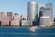 یک قایق بادبانی در رودخانه هادسون در نزدیکی منهتن جنوبی
 -

-

-

-

-
-

-

-
-

-
-


_IMG_3981.JPG)
منابع
[ویرایش]پیوند به بیرون
[ویرایش]Text is available under the CC BY-SA 4.0 license; additional terms may apply.
Images, videos and audio are available under their respective licenses.
