دریاچه میشیگان
| دریاچه میشیگان | |
|---|---|
 | |
 | |
| موقعیت | |
| گروه | دریاچههای بزرگ |
| مختصات | ۴۴° شمالی ۸۷° غربی / ۴۴°شمالی ۸۷°غربی |
| کشورهای حوضه | USA |
| بیشترین درازا | ۳۰۷ مایل (۴۹۴ کیلومتر) |
| بیشترین پهنا | ۱۱۸ مایل (۱۹۰ کیلومتر) |
| مساحتِ رو | ۲۲٬۳۰۰ مایل مربع (۵۸٬۰۰۰ کیلومتر مربع) |
| میانگین ژرفا | ۲۷۹ فوت (۸۵ متر) |
| بیشترین ژرفا | ۹۲۳ فوت (۲۸۱ متر) |
| حجم آب | ۱٬۱۸۰ مایل مکعب (۴٬۹۰۰ کیلومتر مکعب) |
| طول کرانه۱ | ۱٬۶۳۸ مایل (۲٬۶۳۶ کیلومتر) |
| ارتفاع سطح | ۵۷۷ فوت (۱۷۶ متر) |
| ۱ درازای ساحل سنجش خوشتعریفی نیست. | |
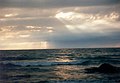
دریاچه میشیگان (به انگلیسی: Lake Michigan) یکی از دریاچههای بزرگ واقع در آمریکای شمالی است که در ایالات متحده آمریکا قرار گرفتهاست. به لحاظ مساحت دریاچه میشیگان سومین دریاچه بزرگ از دریاچه های آب شیرین آمریکا میباشد و از لجاظ حجم آب دومین دریاچه پر حجم از دریاچههای بزرگ میباشد. دریاچه میشیگان همچنین تنها دریاچهای از دریاچههای بزرگ میباشد که بطور کامل در داخل ایالات متحده واقع است. این دریاچه همچنین از نظر مساحت بزرگترین دریاچه جهان میباشد که بطور کامل در داخل خاک ایالات متحده قرار دارد مابقی دریاچهها از پنج دریاچه بزرگ بطور مشترک در خاک آمریکا و کانادا واقع میباشند.

نگارخانه
[ویرایش]-
-

-

-

-
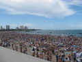 ساحل دریاچه میشیگان در کنار خیابان نورث در شهر شیکاگو
 -


منابع
[ویرایش]- ↑ National Geophysical Data Center بایگانیشده در آوریل ۳, ۲۰۱۵ توسط Wayback Machine, 1996. Bathymetry of Lake Michigan. National Geophysical Data Center, NOAA. doi:10.7289/V5B85627 [access date: March 23, 2015].
- ↑ National Geophysical Data Center بایگانیشده در آوریل ۳, ۲۰۱۵ توسط Wayback Machine, 1999. Bathymetry of Lake Huron. National Geophysical Data Center, NOAA. doi:10.7289/V5G15XS5 [access date: March 23, 2015]. (only small portion of this map)
- ↑ National Geophysical Data Center, 1999. Global Land One-kilometer Base Elevation (GLOBE) v.1. بایگانیشده در فوریه ۱۰, ۲۰۱۱ توسط Wayback Machine Hastings, D. and P.K. Dunbar. National Geophysical Data Center, NOAA. doi:10.7289/V52R3PMS [access date: March 16, 2015].
- ↑ "About Our Great Lakes: Tour". National Oceanic and Atmospheric Administration (NOAA), Great Lakes Environmental Research Laboratory (GLERL). Archived from the original on May 7, 2017. Retrieved December 15, 2017.
دریاچههای بزرگ آمریکای شمالی | ||
|---|---|---|
| دریاچههای اصلی |  | |
| دریاچههای فرعی |
| |
| خلیجها و آبراههها |
| |
| جزیرهها |
| |
| عمومی | |
|---|---|
| کتابخانههای ملی | |
| سایر | |
Text is available under the CC BY-SA 4.0 license; additional terms may apply.
Images, videos and audio are available under their respective licenses.
Cover photo is available under {{::mainImage.info.license.name || 'Unknown'}} license.
Cover photo is available under {{::mainImage.info.license.name || 'Unknown'}} license.
Credit:
(see original file).
