Sarajevu
| Sarajevu | ||||
|---|---|---|---|---|
| Entidad subnacional | ||||
 | ||||
 Ubicación de Sarajevu | ||||
| Coordenadas | 43°51′23″N 18°24′47″E / 43.856388888889, 18.413055555556 | |||
| Entidad | Ciá, Gran cidá, City of Bosnia and Herzegovina y Capital federal | |||
| • País | Prantilla:Geodatos Bósnia Ercegovina | |||
| Superficii | ||||
| • Total | 141,5 km² | |||
| Altol | ||||
| • Media | 518 m s. n. m. | |||
| Puebración (2013) | ||||
| • Total | 275524 hab. | |||
| • Densidá | 1947,17 hab/km² | |||
| Huso horario | Hora de Europa Central | |||
| Código postal | 71000 | |||
| Prefijo telefónico | 033 | |||
| Sitio web oficial | ||||
Sarajevu (En serbobosniu Sarajevo, en alfabetu cirílicu: Сарајево, pronunciau [sǎrajeʋo]) es la cía más grandi i la capital dela repúbrica de Bósnia Ercegovina[1] i dela Federación de Bósnia Ercegovina.
S'alcuentra enos Alpis Dináricus, ena región de Bósnia.
Es el centru políticu, coltural i económicu del país.
Geografia
[Edital | Editá'l códigu]
Assistiamentu
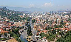
[Edital | Editá'l códigu]La ciá s'alcuentra nel valli de Sarajevu, nel mediu delos Alpis Dináricus. El ríu Miljacka[2] cruza la ciá de esti a oesti.
varius bosquis , colinas i montañas roean el valli.
El monti Treskavica es la más altu (2,088). otrus quatru montis (llamaus Montis Olímpicus)[3] roean la ciá.
Estoria
[Edital | Editá'l códigu]Yugoslavia
[Edital | Editá'l códigu]Nel 1984 la ciá celebró los XIV Juegus Olímpicus de iviernu.[4]
Sitiu de Sarajevu i Guerra de Bósnia
[Edital | Editá'l códigu]La ciá hue gravimenti dañá tras sufrir el sitiu más largu dela estoria moderna
Estau de Bósnia Ercegovina
[Edital | Editá'l códigu]Ogañu es la capital dela repúbrica de Bósnia Ercegovina i dela Federación de Bósnia Ercegovina.
La su recostrución continúa.
Demografia
[Edital | Editá'l códigu]Pueblación
[Edital | Editá'l códigu]Composición étnica
[Edital | Editá'l códigu]| Composición étnica dela ciá de Sarajevo por monicipius, censo de 2013 | ||||||
| Monicipius | Total | Bósnius | Sérbius | Croatas | Otrus | |
| Centar | 55,181 | 41,702 (75.57%) | 2,186 (3.96%) | 3,333 (6.04%) | 7,960 (14.42%) | |
| Novi Grad | 118,553 | 99,773 (84.16%) | 4,367 (3.68%) | 4,947 (4.17%) | 9,466 (7.98%) | |
| Novo Sarajevo | 64,814 | 48,188 (74.35%) | 3,402 (5.25%) | 4,639 (7.16%) | 8,585 (13.24%) | |
| Stari Grad | 36,976 | 32,794 (88.69%) | 467 (1.3%) | 685 (1.85%) | 3,030 (8.19%) | |
| Total | 275,524 | 222,457 (80.74%) | 10,422 (3.78%) | 13,604 (4.94%) | 29,041 (10.54%) | |
Transporti
[Edital | Editá'l códigu]Trenvía
[Edital | Editá'l códigu]La redi de trenvía de Sarajevu enfunciona dendi 1885.
Huentis
[Edital | Editá'l códigu]- ↑ «Archive copy». Archivado desde el original el 25 de diciembre de 2018. Consultado el 22 de junio de 2019.
- ↑ https://www.britannica.com/place/Sarajevo
- ↑ «Archive copy». Archivado desde el original el 22 de marzo de 2019. Consultado el 22 de junio de 2019.
- ↑ http://www.stevesachs.com/papers/paper_sarajevo.html
- ↑ http://www.statistika.ba/?show=12&id=11584#link2
- ↑ http://www.statistika.ba/?show=12&id=10871
- ↑ http://www.statistika.ba/?show=12&id=11568
- ↑ http://www.statistika.ba/?show=12&id=10839
Text is available under the CC BY-SA 4.0 license; additional terms may apply.
Images, videos and audio are available under their respective licenses.


