Santorini
| Santorini | |
|---|---|
 | |
| Datu orokorrak | |
| Garaiera | 567 m |
| Mota | uharte eta helmuga turistiko |
| Azalera | 79,194 km² |
| Geografia | |
 | |
| Koordenatuak | 36°24′54″N 25°25′57″E / 36.415°N 25.4325°E |
| UTC ordua | UTC+02:00 eta UTC+03:00 |
| Honen parte da | Zikladeak Santorini archipelago (en) |
| Kokapena | Egeo |
| Estatu burujabe | |
| Decentralized administration of Greece | Decentralized Administration of the Aegean |
| Eskualdea | Hego Egeo |
| Unitate periferikoa | Thira Regional Unit |
| Udalerria | Thira Municipality |
| Ur-gorputza | Egeo |
Santorini edo Thera (grezieraz: Θήρα) Egeo itsasoaren hegoaldean dagoen uhartedia da, Grezia kontinentaletik 200 kilometrotara hego-ekialderantz kokaturik. Uhartedia Zikladeetako bat da, 73 km² eta 17.430 biztanle inguru ditu.
Geografia
[aldatu | aldatu iturburu kodea]Santorini sumendi-leherketa handiak sortu zuen. Erdialdeko aintzirak 12 km luzera eta 7 km zabalera ditu. Hiru laurdenak, uharte handian daude eta bestea Therasia izeneko uharte txikian. Fira hiriburua uharte handian dago.
Santorinik Fira udalerria (12.440 bizt.) eta Oia komunitatea (grezieraz: Οία, 1.230 biztanle, hauetatik 268 Therasian bizi direnak) ditu. Uhartedia guztira 90,62 km² azalera du, Nea Kameni, Palaia Kameni, Aspronisi eta Christiani biztanlerik gabeko uhartetxoak kontuan hartuta.
Klima
[aldatu | aldatu iturburu kodea]| | |||||||||||||
|---|---|---|---|---|---|---|---|---|---|---|---|---|---|
| Hila | Urt | Ots | Mar | Api | Mai | Eka | Uzt | Abu | Ira | Urr | Aza | Abe | Urtekoa |
| Batez besteko tenperatura maximoa (°C) | 14 | 14 | 16 | 18 | 23 | 27 | 29 | 29 | 26 | 23 | 19 | 15 | 21.1 |
| Batez besteko tenperatura (ºC) | 12 | 12 | 14 | 16 | 20 | 24 | 26 | 26 | 24 | 21 | 17 | 13 | 18.8 |
| Batez besteko tenperatura minimoa (°C) | 10 | 10 | 11 | 13 | 17 | 21 | 23 | 23 | 21 | 18 | 14 | 11 | 16 |
| Pilatutako prezipitazioa (mm) | 71 | 43 | 40 | 16 | 11 | 0 | 7 | 0 | 11 | 38 | 59 | 75 | 371 |
| Prezipitazio egunak (≥ 1.0 mm) | 10 | 9 | 7 | 4 | 3 | 0 | 1 | 0 | 2 | 4 | 8 | 11 | 59 |
| Iturria: holiday-weather.com[1] | |||||||||||||
Historia
[aldatu | aldatu iturburu kodea]
Duela 3.500 urte izandako erupzioaren eraginez, sortutako tsunamiak Kretako kosta suntsitu zuen eta orduko zibilizazio minoikoaren desagerpena eragin. Aditu batzuen ustetan gertaera hau Platonen iturburua zen Atlantidaren mitoa idazteko Kritias bere liburuan.[2]
Izena
[aldatu | aldatu iturburu kodea]Gaur egungo izena (grezieraz: Σαντορίνη) jatorriz italiarra da, izan ere Erdi Aroko veneziar merkatariek izena Tesalonikako Santa Ireneren omenez jarri zioten. Lehen Kallistē ("ederrena"), Strongylē ("biribila") edo Thera zituen izenez.
Galeria
[aldatu | aldatu iturburu kodea]-
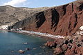 Santoriniko hondartza gorria
 -
 Ikuspegi panoramikoa
 -
 Itsasargia, Akrotiri
 -
 Fira
Fira -
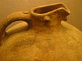 Ontzia Akrotirin aurkitua
 -
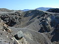 Santoriniko sumendi kraterrak
 -
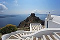 Eskailera Firan
 -
 Santoriniko haize-errotak


Erreferentziak
[aldatu | aldatu iturburu kodea]- ↑ (Ingelesez) holiday-weather.com. Weather Averages for Santorini, Greece. .
- ↑ Greene, MT. (2000). Natural Knowledge in Preclassical Antiquity. Johns Hopkins University Press ISBN 978-0-8018-6371-4..
Kanpo estekak
[aldatu | aldatu iturburu kodea]- (Ingelesez) Therako leherketa
- (Ingelesez) (Frantsesez) Santoriniren webgunea
Text is available under the CC BY-SA 4.0 license; additional terms may apply.
Images, videos and audio are available under their respective licenses.
