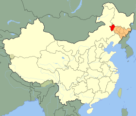
Baicheng
| Baicheng | |
|---|---|
| Prefektura mailako hiria | |
 | |
| Administrazioa | |
| Estatu burujabe | |
| Txinako probintzia | Jilin |
| Izen ofiziala | 白城市 |
| Posta kodea | 137000 |
| Geografia | |
| Koordenatuak | 45°36′53″N 122°49′55″E / 45.6148°N 122.832°E |
 | |
 | |
| Azalera | 25.758,73 km² |
| Altuera | 154 m |
| Demografia | |
| Biztanleria | 2.032.356 (2010) |
| Dentsitatea | 79 bizt/km² |
| Informazio gehigarria | |
| Telefono aurrizkia | 0436 |
| Ordu eremua | UTC+08:00 |
| Matrikula | 吉G |
| bc.jl.gov.cn | |
Baicheng (txinera sinplifikatuz: 白城; pinyineraz: Báichéng), Jilin probintzian kokatutako prefektura mailako hiria da. Guztira, 2.029.000 biztanle inguru dauzka 2007ko erroldaren arabera eta 25.692 kilometro koadroko azalera.
Inguru naturala eta kokapena
[aldatu | aldatu iturburu kodea]Prefektura mailako Baicheng hiriaren mugakideak honakoak dira: Songyuan ekialdean, Heilongjiang probintzia iparraldean, eta Barne Mongolia eskualde autonomoa mendebalde eta hegoaldean.
Banaketa administratiboa
[aldatu | aldatu iturburu kodea]- Taobei Barrutia (洮北区 Táoběi Qū)
- Da'an Hiria (大安市 Dà'ān Shì)
- Taonan Hiria (洮南市 Táonán Shì)
- Zhenlai Konderria (镇赉县 Zhènlài Xiàn)
- Tongyu Konderria (通榆县 Tōngyú Xiàn)
Klima
[aldatu | aldatu iturburu kodea]| | |||||||||||||
|---|---|---|---|---|---|---|---|---|---|---|---|---|---|
| Hila | Urt | Ots | Mar | Api | Mai | Eka | Uzt | Abu | Ira | Urr | Aza | Abe | Urtekoa |
| Erregistraturiko tenperatura maximoa (°C) | 5.9 | 12.8 | 24.3 | 31.2 | 38.1 | 38.6 | 37.3 | 37.7 | 31.7 | 29.8 | 17.5 | 7.2 | ' |
| Batez besteko tenperatura maximoa (°C) | −9.1 | −4.1 | 4.3 | 14.9 | 22.5 | 26.9 | 28.5 | 27.2 | 21.7 | 13.0 | 1.3 | −6.9 | 11.7 |
| Batez besteko tenperatura (ºC) | -16.4 | -11.7 | -2.7 | 7.6 | 15.7 | 20.9 | 23.4 | 21.5 | 14.9 | 6.0 | -5.1 | -13.6 | 5 |
| Batez besteko tenperatura minimoa (°C) | −22.4 | −18.3 | −10.1 | -0.1 | 8.2 | 14.8 | 18.3 | 16.0 | 8.4 | -0.3 | −10.6 | −19.0 | -1.3 |
| Erregistraturiko tenperatura minimoa (°C) | -38.1 | -30.3 | -26.0 | -13.6 | -4.4 | 3.7 | 8.7 | 7.1 | -2.9 | -19.6 | -29.3 | -35.1 | ' |
| Pilatutako prezipitazioa (mm) | 0.5 | 1.2 | 4.5 | 13.7 | 27.6 | 80.8 | 130.6 | 82.0 | 37.3 | 15.4 | 3.2 | 1.6 | 398.4 |
| Prezipitazio egunak (≥ 1 mm) | 1.4 | 2.0 | 2.9 | 3.9 | 6.8 | 11.3 | 12.5 | 10.5 | 7.4 | 4.0 | 2.6 | 2.5 | 67.8 |
| Iturria: [1] | |||||||||||||
Ikus, gainera
[aldatu | aldatu iturburu kodea]Erreferentziak
[aldatu | aldatu iturburu kodea]- ↑ Weather.com.cn. Accessed 2011-05-28.
Kanpo estekak
[aldatu | aldatu iturburu kodea]- (Txineraz) Baicheng hiriko gobernuaren webgunea.
| Jilin probintziako udalerriak | ||
|---|---|---|
|
Baicheng • Baishan • Changchun • Jilin Hiria • Liaoyuan • Siping • Songyuan • Tonghua • Yanbian | ||
| Artikulu hau Txinako geografiari buruzko zirriborroa da. Wikipedia lagun dezakezu edukia osatuz. |
Text is available under the CC BY-SA 4.0 license; additional terms may apply.
Images, videos and audio are available under their respective licenses.
