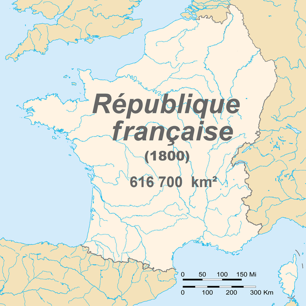
Fail:France 1800.png

Algfail (1795 × 1796 pikslit, faili suurus: 152 KB, MIME tüüp: image/png)
Faili ajalugu
Klõpsa kuupäeva ja kellaaega, et näha sel ajahetkel kasutusel olnud failiversiooni.
| Kuupäev/kellaaeg | Pisipilt | Mõõtmed | Kasutaja | Kommentaar | |
|---|---|---|---|---|---|
| viimane | 6. november 2015, kell 02:01 |  | 1795 × 1796 (152 KB) | TKostolany | suppression des frontières des autres pays car il en manque beaucoup |
| 7. juuni 2010, kell 23:22 |  | 1795 × 1796 (195 KB) | Brisavoine | Added land area. | |
| 4. juuni 2010, kell 06:10 |  | 1795 × 1796 (191 KB) | Brisavoine | Autre correction de frontière dans le Limbourg hollandais. | |
| 4. juuni 2010, kell 04:48 |  | 1795 × 1796 (191 KB) | Brisavoine | Correction de la carte : Genève et Monaco faisaient partie de la République française en 1800. | |
| 4. juuni 2010, kell 04:15 |  | 1795 × 1796 (191 KB) | Brisavoine | Escaut jusqu'à son embouchure. | |
| 4. juuni 2010, kell 04:11 |  | 1795 × 1796 (191 KB) | Brisavoine | Correction de la carte : la Flandre zélandaise faisait partie de la République française en 1800. | |
| 19. juuni 2008, kell 19:25 |  | 1795 × 1796 (346 KB) | European citizen | ((Information |Description=((en|1=Map of France in 1800)) ((fr|1=Carte de la première république française en 1800)) |Source=travail personnel (own work) |Author=European citizen |Date=19 juin 2008 |Permission=domaine public | |
Faili kasutus
Seda faili kasutab järgmine lehekülg:
Globaalne failikasutus
Järgmised muud vikid kasutavad seda faili:
- Faili kasutus vikis ar.wikipedia.org
- Faili kasutus vikis ast.wikipedia.org
- Faili kasutus vikis bg.wikipedia.org
- Faili kasutus vikis ca.wikipedia.org
- Faili kasutus vikis de.wikipedia.org
- Faili kasutus vikis en.wikipedia.org
- Faili kasutus vikis es.wikipedia.org
- Faili kasutus vikis eu.wikipedia.org
- Faili kasutus vikis fr.wikipedia.org
- Faili kasutus vikis fr.wikinews.org
- Catégorie:22 septembre 2008
- Catégorie:22 septembre 2009
- Catégorie:22 septembre 2010
- Catégorie:22 septembre 2011
- Catégorie:22 septembre 2012
- Modèle:Éphéméride-22 septembre
- Évènements du 22 septembre 2012
- Catégorie:22 septembre 2013
- Évènements du 22 septembre 2013
- Catégorie:22 septembre 2014
- Évènements du 22 septembre 2014
- Catégorie:22 septembre 2015
- Évènements du 22 septembre 2015
- Catégorie:22 septembre 2016
- Évènements du 22 septembre 2016
- Catégorie:22 septembre 2017
- Évènements du 22 septembre 2017
- Catégorie:22 septembre 2018
- Évènements du 22 septembre 2018
- Catégorie:22 septembre 2019
- Évènements du 22 septembre 2019
- Catégorie:22 septembre 2020
- Évènements du 22 septembre 2020
- Catégorie:22 septembre 2021
- Catégorie:22 septembre 2022
- Catégorie:22 septembre 2023
Vaata selle faili globaalset kasutust.
Metaandmed
Text is available under the CC BY-SA 4.0 license; additional terms may apply.
Images, videos and audio are available under their respective licenses.
