Transleitania
| Tierras de la Corona de San Esteban A Magyar Szent Korona Országai Zemlje krune svetog Stjepana Земље круне Светог Стефана Krajiny Svätoštefanskej koruny Țările Coroanei Sfântului Ștefan | ||||||||||||||||||||||||||||||||||||||||||||||||
|---|---|---|---|---|---|---|---|---|---|---|---|---|---|---|---|---|---|---|---|---|---|---|---|---|---|---|---|---|---|---|---|---|---|---|---|---|---|---|---|---|---|---|---|---|---|---|---|---|
| Estado constituyente del Imperio austrohúngaro | ||||||||||||||||||||||||||||||||||||||||||||||||
| 1867-1918 | ||||||||||||||||||||||||||||||||||||||||||||||||
| ||||||||||||||||||||||||||||||||||||||||||||||||
 Mapa del Imperio austrohúngaro, Transleitania en verde. | ||||||||||||||||||||||||||||||||||||||||||||||||
| Capital | Budapest | |||||||||||||||||||||||||||||||||||||||||||||||
| Entidad | Estado constituyente del Imperio austrohúngaro | |||||||||||||||||||||||||||||||||||||||||||||||
| • País | Imperio austrohúngaro | |||||||||||||||||||||||||||||||||||||||||||||||
| Historia | ||||||||||||||||||||||||||||||||||||||||||||||||
| • 1867 | Establecido | |||||||||||||||||||||||||||||||||||||||||||||||
| • 1918 | Disuelto | |||||||||||||||||||||||||||||||||||||||||||||||
| ||||||||||||||||||||||||||||||||||||||||||||||||


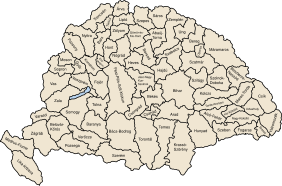
Transleitania (en alemán: Transleithanien) fue el nombre alemán de la parte húngara del Imperio austrohúngaro, la monarquía dual creada en 1867 y disuelta en 1918. Las tierras transleitanas también se denominaron Tierras de la Corona de San Esteban y, en terminología medieval, Archiregnum Hungaricum («Alto Reino de Hungría»).
El nombre latino Transleitania se deriva del río Leita (Lajta), y se le aplica por encontrarse en su mayor parte al este del río (o «allende», desde la perspectiva austriaca). Del mismo modo, Cisleitania, las tierras del Imperio austríaco en la monarquía dual, se encontraba al oeste del río Leita.
Transleitania se componía del Reino de Hungría (Magyar Királyság), que incluía la región autónoma de Croacia-Eslavonia (Horvát-Szlavónia Királyság), y el puerto franco de Rijeka (Fiume).
Véase también
[editar]Enlaces externos
[editar] Wikimedia Commons alberga una categoría multimedia sobre Transleitania.
Text is available under the CC BY-SA 4.0 license; additional terms may apply.
Images, videos and audio are available under their respective licenses.


