Santibáñez de Montes
| Santibáñez de Montes | ||
|---|---|---|
| localidad | ||
 Santibáñez de Montes | ||
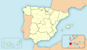
| Ubicación de Santibáñez de Montes en España | ||
| Ubicación de Santibáñez de Montes en la provincia de León | ||
| País |
| |
| • Com. autónoma |
| |
| • Provincia |
| |
| • Comarca | El Bierzo | |
| • Partido judicial | Ponferrada | |
| • Municipio | Torre del Bierzo | |
| Ubicación | 42°33′57″N 6°16′52″O / 42.565959, -6.280994 | |
| • Altitud | 1005 m | |
| Población | 0 hab. (INE 2018) | |
| Código postal | 24379 | |
| Pref. telefónico | 987 | |
| Patrón | Juan el Evangelista | |
Santibáñez de Montes es una localidad del municipio de Torre del Bierzo, en la comarca de El Bierzo, provincia de León, Castilla y León, España.

Localidades limítrofes
[editar]Confina con las siguientes localidades:
- Al norte con Montealegre.
- Al noreste con Ucedo.
- Al este con Veldedo.
- Al sureste con Viforcos y Argañoso.
- Al sur con La Maluenga.
- Al suroeste con Fonfría.
- Al oeste con San Facundo.
- Al noroeste con Santa Cruz de Montes.
Demografía
[editar]Después de estar deshabitado por más de cuarenta años el Boletín Oficial de Castilla y León anunció la supresión de la entidad a partir de abril de 2010 debido a que no existían vecinos empadronados y había una ausencia reiterada de órganos de gobierno.[1]
Historia
[editar]Así se describe a Santibáñez de Montes en el tomo VI del Diccionario geográfico-estadístico-histórico de España y sus posesiones de Ultramar, obra impulsada por Pascual Madoz a mediados del siglo XIX:[2]
Localidad en la provincia de León, partido judicial de Ponferrada, diócesis de Astorga, audiencia territorial y capitanía general de Valladolid, ayuntamiento de Albares de la Ribera. Situado en terreno llano a 400 varas del camino que se dirige de Astorga a León; su clima es bastante sano. Tiene 24 casas, Iglesia parroquial de San Juan Evangelista, anejo de Santa Cruz de Montes, y buenas aguas potables. Confina con su matriz (Santa Cruz de Montes) y Poibueno. El terreno es montuoso en su mayor parte. Los caminos son locales. Recibe la correspondencia de la cabeza de partido (Ponferrada). Produce granos, legumbres, lino y pastos para el ganado que cría. Población: 25 vecinos, 102 almas. Contribuye con el ayuntamiento.Diccionario geográfico-estadístico-histórico de España y sus posesiones de Ultramar
Referencias
[editar]- ↑ Ramírez, Cristóbal. "Los últimos del lugar". en El País Semanal. 1 de agosto de 2010 P. 43.
- ↑ Madoz, Pascual (1989). Diccionario geográfico-estadístico-histórico de España y sus posesiones de ultramar. Biblioteca Santa Ana. ISBN 978-84-600-7318-5.
Enlaces externos
[editar] Wikimedia Commons alberga una categoría multimedia sobre Santibáñez de Montes.
Text is available under the CC BY-SA 4.0 license; additional terms may apply.
Images, videos and audio are available under their respective licenses.


