Saarburg
| Saarburg | ||
|---|---|---|
| Ciudad | ||
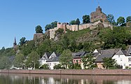
 El castillo sobre la ribera del Sarre
| ||
 Escudo | ||
 Saarburg Localización de Saarburg en Renania-Palatinado | ||
 Ubicación en el distrito | ||
| Coordenadas | 49°36′33″N 6°33′01″E / 49.609166666667, 6.5502777777778 | |
| Entidad | Ciudad | |
| • País | Alemania | |
| • Estado federado | Renania-Palatinado | |
| • Distrito | Tréveris-Saarburg | |
| • Verbandsgemeinde | Saarburg-Kell | |
| Alcalde | Jürgen Dixius (CDU) | |
| Subdivisiones | 4 Stadtteile | |
| Superficie | ||
| • Total | 20.63 km² | |
| Altitud | ||
| • Media | 160 m s. n. m. | |
| Población (31 de diciembre de 2019) | ||
| • Total | 7381 hab.[1] | |
| • Densidad | 358 hab./km² | |
| Huso horario | CET (UTC +1) | |
| • en verano | CEST (UTC +2) | |
| Código postal | 54439[2] | |
| Prefijo telefónico | 06581 | |
| Matrícula | TR y SAB | |
| Número oficial de comunidad | 07235118 | |
| Sitio web oficial | ||
Saarburg o Sarreburgo es una ciudad del distrito de Tréveris-Saarburg, en el estado federado de Renania-Palatinado de Alemania, situada a unos 30 km de la frontera con Francia y a unos 20 km de la frontera con Luxemburgo. Se encuentra al oeste del parque natural de Saar-Hunsrück, en la orilla del Río Sarre y en la desembocadura del Leukbach. Saarburg es la sede administrativa de la Verbandsgemeinde Saarburg-Kell.

Historia
[editar]La historia de la ciudad comienza con la construcción del castillo, hoy en ruinas, por el conde Sigfrido de Luxemburgo en el año 964. Recibió su carta municipal en 1291 del rey Rodolfo I de Habsburgo. La villa fue adjudicada a Prusia por el Congreso de Viena. A raíz de la Segunda Guerra Mundial, permaneció ocupada hasta 1948 por tropas luxemburguesas, y desde entonces hasta 1955 por tropas francesas. De 1968 a 2010 fue la sede de un batallón francés.
Galerìa
[editar]-
 Saarburg, la fortaleza y la Ober- y Unterstadt
 -
 Saarburg, la iglesia catolica (Pfarrkirche Sankt Laurentius)
 -
 La iglesia protestante y el rio Sarre en Saarburg
 -
 El rio Sarre en Saarburg


Economía
[editar]En Saarburg funcionó desde el siglo XVIII una importante fundición de campanas, activa hasta principios de este siglo y convertida hoy en museo. La ciudad es un importante centro vinícola, gracias a los viñedos de uva Riesling plantados en el área circundante.
Referencias
[editar]- ↑ Statistisches Landesamt Rheinland-Pfalz – Bevölkerungsstand 2019, Kreise, Gemeinden, Verbandsgemeinden. Consultado el 28 de marzo de 2021 (en alemán).
- ↑ Worldpostalcodes.org, código postal n.º 54439.
Enlaces externos
[editar] Wikimedia Commons alberga una categoría multimedia sobre Saarburg.
- Esta obra contiene una traducción parcial derivada de «Saarburg» de Wikipedia en alemán, concretamente de esta versión del 10 de diciembre de 2020, publicada por sus editores bajo la Licencia de documentación libre de GNU y la Licencia Creative Commons Atribución-CompartirIgual 4.0 Internacional.
Text is available under the CC BY-SA 4.0 license; additional terms may apply.
Images, videos and audio are available under their respective licenses.
