Sáhara argelino
| Sáhara argelino | ||
|---|---|---|
|
الصحراء الجزائرية al-ṣaḥra' al-jazayiria | ||
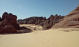
 Desierto de Tamanrasset, en el Sáhara argelino. | ||
| Localización geográfica | ||
| Continente | África | |
| Región | Magreb / Tamazgha | |
| Coordenadas | 27°19′00″N 3°58′00″E / 27.31667, 3.96667 | |
| Localización administrativa | ||
| País |
| |
| Características geográficas | ||
| Tipo | Desierto | |
| Ecorregión | Desierto del Sahara | |
| Superficie | 2 1438 km² | |
| Altitud máxima | Monte Tahat (3.003 m s. n. m.) | |
| Otros accidentes | Macizo Ahaggar | |
| Población | 3 600 000 (2018) | |
| Clima | árido y semiárido | |
| Características históricas | ||
| Primeros pobladores | Bereberes (tuareg) | |
| Mapas | ||
| Sáhara argelino (Grand Sud) | ||

El Sáhara de Argelia, también llamado desierto de Argelia (en árabe, الصحراء الجزائرية al-ṣaḥra' al-jazayiria) y oficialmente, Gran Sur argelino (Grand Sud algérien) es una región que se encuentra en el norte de África, llamado localmente Maġreb o Tamazġa, y es parte del desierto del Sáhara. El desierto ocupa más de cuatro quintos del territorio argelino. Al norte, el desierto limita con las Altas Mesetas de las que le separa el Atlas sahariano. Comienza siendo un desierto de piedras, y cuanto más «tierra adentro» se avanza (sur), más se convierte en un desierto de dunas de arena. En el sudeste se encuentra la cordillera Tassili n'Ajjer, la cual posee un gran valor arqueológico y fue incluida en la lista del Patrimonio de la Humanidad por la UNESCO en 1982.[1] El área es conocida por su extrema aridez y calor extremo, ya que las temperaturas durante el día están comúnmente entre 46 °C y 51 °C durante el período más caluroso del año en la mayor parte del desierto. Ciudades y pueblos como Uargla, Tuggurt, Beni Abbés, Adrar o In Salah se encuentran entre los lugares más calurosos de la Tierra durante el verano. La precipitación media anual es muy inferior a 100 mm en la parte más septentrional, pero el centro y la parte sur reciben mucho menos de 50 mm y, por lo tanto, son hiperáridos y se encuentran entre los lugares más secos de la Tierra.
Referencias
[editar]- ↑ «Tassili n'Ajjer - UNESCO World Heritage Centre». Whc.unesco.org. Consultado el 18 de marzo de 2013.
Text is available under the CC BY-SA 4.0 license; additional terms may apply.
Images, videos and audio are available under their respective licenses.

