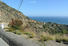
Ruta Estatal de California 23
Ruta Estatal de California 23 | |||||||||
|---|---|---|---|---|---|---|---|---|---|
|
| |||||||||
 Primera milla de la SR 23 | |||||||||
 Mapa de la Ruta Estatal de California 23 | |||||||||
| Datos de la ruta | |||||||||
| Identificador | 23 | ||||||||
| Tipo | Ruta Estatal | ||||||||
| Longitud | 51,5 km (32.030 mi) | ||||||||
| Administración | |||||||||
| Administración | Caltrans | ||||||||
| Orientación | |||||||||
| • Sur |
| ||||||||
| • Norte |
| ||||||||
| Cruces |
| ||||||||
| Ubicación | 34°04′10″N 118°53′37″O / 34.069369, -118.893614 | ||||||||
| Siguientes rutas | |||||||||
| |||||||||


La Ruta Estatal de California 23, y abreviada SR 23 (en inglés: California State Route 23) es una carretera estatal estadounidense ubicada en el estado de California. La carretera inicia en el Sur desde la SR 1 en Malibú hacia el Norte en la SR 126 en Fillmore. La carretera tiene una longitud de 51,5 km (32.030 mi).[1]
Mantenimiento
[editar]Al igual que las autopistas interestatales, y las rutas federales y el resto de carreteras estatales, la Ruta Estatal de California 23 es administrada y mantenida por el Departamento de Transporte de California por sus siglas en inglés Caltrans.
Cruces
[editar]La Ruta Estatal de California 23 es atravesada principalmente por la ![]() US 101
US 101 ![]() SR 118 en Thousand Oaks y Moorpark.
SR 118 en Thousand Oaks y Moorpark.
| Condado | Localidad | Miliario [2][3][4] |
Salida [5] |
Destinos | Notas |
|---|---|---|---|---|---|
| Los Ángeles LA 0.00-8.90 |
Malibú | 0.00 | |||
| Ventura VEN 0.00-24.17 |
Thousand Oaks | T1.49 | Portrero Road – Hidden Valley | ||
| R2.26 | Triunfo Canyon Road | ||||
| R2.88 | Agoura Road, Hampshire Road | ||||
| R3.32 0.70[N 1] |
Interchange; extremo sur de la US 101 | ||||
| Extremo sur de la autopista en la US 101 | |||||
| 1.62[N 1] | 41 | Hampshire Road | |||
| 3.11[N 1] R3.34 |
12B | Extremo norte de la US 101; sin salida en sentido norte | |||
| R3.70 | 13 | Hillcrest Drive, Thousand Oaks Boulevard – Thousand Oaks | Salida Sur y entrada Norte | ||
| R5.06 | 14 | Janss Road | |||
| R6.03 | 15 | Avenida de los Árboles | |||
| R7.17 | 16 | Sunset Hills Boulevard | |||
| R8.21 | 17 | Olsen Road – Simi Valley | |||
| Moorpark | R10.16 | 19 | Tierra Rejada Road | ||
| Extremo norte de la autopista | |||||
| R11.43 T18.21[N 2] |
20B | Interchange; extremo sur de la SR 118 | |||
| R17.49[N 2] R12.90 |
Extremo norte de la SR 118 | ||||
| Fillmore | 24.17 | ||||
| 24.17 | A Street | Continuación más allá de la SR 126 | |||
| 1.000 mi = 1.609 km; 1.000 km = 0.621 mi Cerrada/Antigua • Terminal concurrente • Acceso incompleto • Propuesta/Sin abrir | |||||
Véase también
[editar] Portal:California. Contenido relacionado con California.
Referencias
[editar]- ↑ Google. «Google Maps –Recorrido de la Ruta Estatal de California 23». Google. Consultado el 14 de septiembre de 2011.
- ↑ Departamento de Transporte de California, State Truck Route List (XLS file), consultado en febrero de 2008
- ↑ Departamento de Transporte de California, Log of Bridges on State Highways, Julio de 2007
- ↑ Departamento de Transporte de California, All Traffic Volumes on CSHS, 2005 y 2006
- ↑ Departamento de Transporte de California, California Numbered Exit Uniform System, State Route 23 Freeway Interchanges, U.S. Route 101 Freeway Interchanges, Consultado en 2009-02-05.
Enlaces externos
[editar] Wikimedia Commons alberga una categoría multimedia sobre Ruta Estatal de California 23.
- Página oficial de Caltrans
Text is available under the CC BY-SA 4.0 license; additional terms may apply.
Images, videos and audio are available under their respective licenses.
