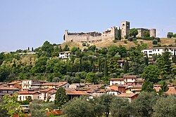
Padenghe sul Garda
| Padenghe sul Garda | ||
|---|---|---|
| Entidad subnacional | ||
 | ||
|
Localización de Padenghe sul Garda en Italia | ||
 | ||
| Coordenadas | 45°30′30″N 10°30′59″E / 45.508333333333, 10.516388888889 | |
| Capital | Padenghe sul Garda | |
| Idioma oficial | Italiano | |
| Entidad | Comuna de Italia | |
| • País | Italia | |
| • Región | Lombardía | |
| • Provincia | Brescia | |
| Municipios limítrofes | Calvagese della Riviera, Desenzano del Garda, Lonato del Garda, Moniga del Garda, Soiano del Lago | |
| Superficie | ||
| • Total | 20 km² | |
| Altitud | ||
| • Media | 127 m s. n. m. | |
| Población (30-06-2008) | ||
| • Total | 4,213 hab. | |
| • Densidad | 178 hab./km² | |
| Huso horario | CET (UTC +1) | |
| • en verano | CEST (UTC +2) | |
| Código postal | 25080[1] | |
| Prefijo telefónico | 030 | |
| Matrícula | BS | |
| Código ISTAT | 017129 | |
| Código catastral | G213[2] | |
| Fiestas mayores | 22 de noviembre | |
| Patrono(a) | San Emiliano | |
| Sitio web oficial | ||
Padenghe sul Garda es un municipio italiano que tiene más de 4.000 habitantes y se halla en la provincia de Brescia, en las orillas del Lago de Garda.
Lugares de interés
[editar]- El Castillo. En un cerro, en el casco antiguo de Padenghe, se encuentran las ruinas de un viejo castillo medieval del siglo IX. A lo mejor se trata del castillo más antiguo de la Valtenesi. En el castillo, que fue ampliado en el siglo XIV, se sitúan unas habitaciones.
Transportes
[editar]Aeropuertos
[editar]El aeropuerto más cercano es el de Montichiari; pero el de Orio al Serio y el de Verona se encuentran a poca distancia.
Conexiones viales
[editar]La conexión vial principal es la autopista A4 Turín-Milán–Venecia-Trieste y tiene una salida en el municipio de Desenzano del Garda, que está bastante cerca.
Conexiones ferroviarias
[editar]En Moniga del Garda no hay estaciones de ferrocarril. La más cercana es la de Desenzano del Garda.
Conexiones navales
[editar]Transportes urbanos
[editar]Evolución demográfica
[editar]| Gráfica de evolución demográfica de Padenghe sul Garda entre 1861 y 2001 |
 |
|
Fuente ISTAT - elaboración gráfica de Wikipedia |
- ↑ Worldpostalcodes.org, código postal n.º 25080.
- ↑ «Codici Catastali». Comuni-italiani.it (en italiano). Consultado el 29 de abril de 2017.
Text is available under the CC BY-SA 4.0 license; additional terms may apply.
Images, videos and audio are available under their respective licenses.

