Niijima (Tokio)
| Niijima 新島村 | ||
|---|---|---|
| Entidad subnacional | ||
 | ||
 Bandera | ||
|
Localización de Niijima en Japón | ||
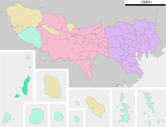
 Mapa de Niijima | ||
| Coordenadas | 34°22′37″N 139°15′24″E / 34.377055555556, 139.25675 | |
| Idioma oficial | Japonés | |
| Entidad | Villa de Japón | |
| • País | Japón | |
| • Región | Kantō | |
| • Prefectura | Prefectura de Tokio | |
| • Distrito | Subprefectura de Ōshima | |
| Dirigentes | ||
| • Alcalde | Hirokazu Ōnuma | |
| Superficie | ||
| • Total | 27,83 km² | |
| Población (1 de mayo de 2010) | ||
| • Total | 3,040 hab. | |
| • Densidad | 109 hab./km² | |
| Huso horario | Hora estándar de Japón (UTC +9) | |
| Código dantai | 133639[1][2] | |
| Sitio web oficial | ||
Niijima (新島村 Niijima-mura?) es una villa que se encuentra en Tokio, Japón; específicamente en la zona de las islas Izu, dentro de la subprefectura de Ōshima.
Según datos del 2010, el pueblo tiene una población estimada de 3.040 habitantes y una densidad de 109 personas por km². El área total es de 27,83 km².
Fue creado como villa el 1 de octubre de 1923 con el nombre de Niijimahon y añadido a la subprefectura de Ōshima en 1926. Luego el 1 de noviembre de 1954 absorbe la villa de Wakagō. El 1 de abril de 1992 cambió su nombre de Niijimahon a Niijima.
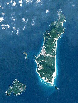
La villa comprende las islas habitadas de Niijima y Shikinejima, al igual que las islas deshabitadas de Udoneshima, Hanshima y Jinaitō. Estas islas se ubican a más o menos unos 160 km al sur de la zona continental de Tokio. La mayor altura es el monte Miyatsuke (432 m) en Niijima. En la isla de Niijima también se ubica el aeropuerto de Niijima y el puerto.
Es conocida por sus onsen.

Enlaces externos
[editar] Wikimedia Commons alberga una categoría multimedia sobre Niijima.
- Página oficial (en japonés)
- ↑ Ministerio de Asuntos Internos y Comunicaciones (10 de octubre de 2016). «都道府県コード及び市区町村コード» [Códigos de prefectura y municipales] (PDF) (en japonés). Consultado el 25 de enero de 2018.
- ↑ Ministerio de Asuntos Internos y Comunicaciones (10 de octubre de 2016). «都道府県コード及び市区町村コード» [Códigos de prefectura y municipales] (XLS) (en japonés). Consultado el 25 de enero de 2018.
Text is available under the CC BY-SA 4.0 license; additional terms may apply.
Images, videos and audio are available under their respective licenses.

