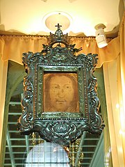
Manoppello
| Manoppello | ||
|---|---|---|
| Entidad subnacional | ||
 | ||
 Escudo | ||
|
Localización de Manoppello en Italia | ||
 | ||
| Coordenadas | 42°15′28″N 14°03′35″E / 42.257777777778, 14.059722222222 | |
| Capital | Manoppello | |
| Idioma oficial | Italiano | |
| Entidad | Comuna de Italia | |
| • País | Italia | |
| • Región | Abruzos | |
| • Provincia | Pescara | |
| Fracciones | Manoppello Scalo, Ripacorbaria, Santa Maria Arabona | |
| Municipios limítrofes | Alanno, Casalincontrada (CH), Chieti (CH), Lettomanoppello, Rosciano, Serramonacesca, Turrivalignani, Scafa | |
| Superficie | ||
| • Total | 39 km² | |
| Altitud | ||
| • Media | 217 m s. n. m. | |
| Población (31-12-04) | ||
| • Total | 6091 hab. | |
| • Densidad | 144 hab./km² | |
| Gentilicio | manoppelleses | |
| Huso horario | CET (UTC +1) | |
| • en verano | CEST (UTC +2) | |
| Código postal | 65024[1] | |
| Prefijo telefónico | 085 | |
| Matrícula | PE | |
| Código ISTAT | 068022 | |
| Código catastral | E892[2] | |
| Fiestas mayores | Tercer Lunes de Mayo | |
| Patrono(a) | Santa Faz | |
| Sitio web oficial | ||
Manoppello es una localidad italiana de 6091 habitantes de la provincia de Pescara.
Historia
[editar]

El origen del nombre del pueblo deriva del "manoppio", pequeña cantidad de grano que cabe en una mano, símbolo que se ve en el escudo del pueblo. Todo ello confirma el origen del nombre de Manoppello que se debe a la unión de las palabras latinas "manus" y "plere", es decir "mano llena". El haz de grano indica la fertilidad de la tierra, que en épocas pasadas, sobre todo en época romana, garantizaba prosperidad y abundancia de las cosechas. De hecho se han hallado restos arqueológicos en la zona que hoy se conoce como Valle Romana, entre los que destaca una villa romana con mosaicos aún intactos. El municipio está dividido en 4 núcleos diferentes: Manoppello, Manoppello Scalo, Santa Maria Arabona y Ripacorbaria. Manoppello es conocida sobre todo por la Santa Faz y la Abadía de Santa María Arabona.
Evolución demográfica
[editar]| Gráfica de evolución demográfica de Manoppello entre 1861 y 2001 |
 |
|
Fuente ISTAT - elaboración gráfica de Wikipedia |
Enlaces externos
[editar] Wikimedia Commons alberga una galería multimedia sobre Manoppello.
- Sitio dedicado a la Santa Faz de Manoppello
- Sitio del Museo dedicado a la tragedia de Marcinelle
- Polish website about Volto Santo di Manoppello
- ↑ Worldpostalcodes.org, código postal n.º 65024.
- ↑ «Codici Catastali». Comuni-italiani.it (en italiano). Consultado el 29 de abril de 2017.
Text is available under the CC BY-SA 4.0 license; additional terms may apply.
Images, videos and audio are available under their respective licenses.

