Kediet Ijill
| Kediet Ijill o Monte Ijill | ||
|---|---|---|
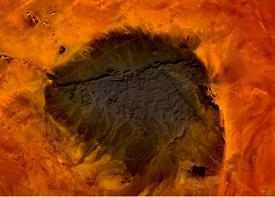
 Imagen desde el espacio del monte Ijill. | ||
| Localización geográfica | ||
| Continente | África | |
| Coordenadas | 22°39′50″N 12°35′22″O / 22.663888888889, -12.589444444444 | |
| Localización administrativa | ||
| País |
| |
| División | Tiris Zemmur | |
| Localización | África Occidental | |
| Características generales | ||
| Tipo | Hematita Magnetita | |
| Altitud | 915 m | |
| Prominencia | 596 metros | |
| Mapa de localización | ||
Kediet Ijill, también conocido como monte Ijill, Kediet ej Jill, Kedia d'Idjil (en francés), Kaedia Idjil, Kedia Idjil, Kediet Ijil, Koedia d'Idjil, Kédiet Ijil y Quediat Iyil[1] es la montaña más alta de Mauritania, con 915 m de altitud. Se encuentra al oeste de Zuérate y al este de F'dérik, cerca de la frontera del Sáhara Occidental, en la región de Tiris Zemmour.
Se encuentra en un lugar desértico con unas precipitaciones que apenas superan los 50 mm. Su color azul grisáceo intenso es debido a los óxidos de hierro, especialmente la magnetita y la hematita. La explotación de hierro se considera desde la década de 1930, cuando Mauritania pertenecía al África Occidental Francesa, y se explota desde 1952 por la empresa minera MIFERMA (Société des mines de fer de Mauritanie).[2] Al nacionalizarse en 1974, el hierro pasa a ser extraído por la Sociedad Nacional Industrial y Minera (Société nationale industrielle et minière, SNIM) por medio de un ferrocarril de 680 km construido expresamente desde el puerto minero de Nuadibú hasta Zuérate.[3]
La kedia o montaña posee varios gueltas o cuencas interiores que forman verdaderas cascadas en época de lluvias, cuando todo el paisaje reverdece, incluidas las acacias espinosas.
El hierro provoca perturbaciones en el campo magnético terrestre. El paisaje es un glacis azul grisáceo seguido de una llanura arenosa salpicada de guelbs, colinas en forma de inselberg en idioma local hassanía. Estos ergs se denominan Agamoun al norte, Azefal, Hammami y Hachya al sur (mapa IGN Port Etienne NF28, 1961).
El ferrocarril ha sido prolongado unos 50 km desde F'dérik hasta Mahoudat para explotar los guelbs del entorno.
Véase también
Text is available under the CC BY-SA 4.0 license; additional terms may apply.
Images, videos and audio are available under their respective licenses.

