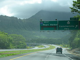
Interestatal H-3
 Interestatal H-3 | |||||||||
|---|---|---|---|---|---|---|---|---|---|
|
| |||||||||
 H-3 al sur de Kaneohe | |||||||||
 Localización de la H-3 | |||||||||
| Datos de la ruta | |||||||||
| Nombre coloquial | John A. Burns Freeway | ||||||||
| Identificador | H-3 | ||||||||
| Tipo | Interestatal | ||||||||
| Inauguración | 1972 | ||||||||
| Longitud | 24,66 km (15.32 mi)[1] | ||||||||
| Orientación | |||||||||
| • Oeste |
| ||||||||
| • Este | Base del Cuerpo de Marines de Hawaii | ||||||||
| Cruces |
| ||||||||
| Ubicación | 21°23′06″N 157°47′09″O / 21.384991, -157.785902 | ||||||||
| Siguientes rutas | |||||||||
| |||||||||
La Interestatal H-3 (abreviada H-3) es una autopista interestatal de trazado este-oeste ubicada en el estado de Hawái, localizada en su totalidad en la isla de Oahu. A pesar de su número esta autopista es de sentido este–oeste y la serie 'H' (para Hawái) refleja el orden en el cual la ruta fue completada y construida. La H-3 se inicia en un intercambio con las Interestatales H-1 y H-201 en Halawa, discurre a través de las montañas Ko'olau hasta llegar a la puerta principal de la Base del Cuerpo de Marines de Hawaii.[2] Esta ruta junto a la Interestatal H-1 cumple la finalidad de defensa nacional al conectar la base del Cuerpo de la Marina con el puerto de Marina de los Estados Unidos en Pearl Harbor.
La H-3 es una de las carreteras interestatales más caras jamás construidas, en base al costo por milla. Su costo final fue de $ 1,3 mil millones o aproximadamente $ 80 millones por milla.[3] La longitud de esta ruta es de 24,66 km (15.32 mi).[4]
Mantenimiento
[editar]Al igual que las carreteras estatales y las carreteras federales, la Interestatal H-3 es administrada y mantenida por el Departamento de Transporte de Hawái por sus siglas en inglés HDOT.
Véase también
[editar] Portal:Hawái. Contenido relacionado con Hawái.
Referencias
[editar]- ↑ «Longitud de la Interestatal H-3». Departamento de Transporte de los Estados Unidos. Consultado el 19 de septiembre de 2011.
- ↑ «Lista de extremos y salidas de la Interestatal H-3». IHOZ.com. Consultado el 19 de septiembre de 2011.
- ↑ Yuen, Mike (3 de diciembre de 1997). «H-3: Open Road». Honolulu Star-Bulletin. Consultado el 27 de marzo de 2011.
- ↑ Google. «Google Maps –Recorrido de la Interestatal H-3». Google. Consultado el 19 de septiembre de 2011.
Enlaces externos
[editar] Wikimedia Commons alberga una categoría multimedia sobre Interestatal H-3.
- Lista de ciudades servidas por autopistas interestatales
- Longitud de la Interestatal H-3 en Hawái
- Lista de Autopistas por estado en AARoads.com
Text is available under the CC BY-SA 4.0 license; additional terms may apply.
Images, videos and audio are available under their respective licenses.
