Interestatal 90
Interestatal 90 | ||
|---|---|---|
|
Indiana, Massachusetts, Wyoming, Washington, Idaho, Montana, Dakota del Sur, Minesota, Wisconsin, Illinois, Ohio, Pensilvania y Nueva York, | ||
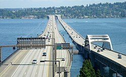
| Archivo:The Dan Ryan Expressway Westbound near the I-55 exit.jpg, Interstate 90 floating bridges after Blue Angels performance - 01.jpg y Boston traffic re-routed Ted Williams tunnel, 2006.jpg | ||
 Ruta principal del Sistema Interestatal de Carreteras | ||
| Datos de la ruta | ||
| Tipo | Autopista Interestatal | |
| Inauguración | 1956 | |
| Longitud | 3101,77 millas (4991,8 km)[1] | |
| Orientación | ||
| • Oeste |
| |
| • Este |
| |
| Cruces |
| |

La Interestatal 90 (abreviada I-90) es la autopista interestatal de trazado este-oeste (costa a costa) más al norte de los Estados Unidos, y la más larga del país con 4.991 kilómetros. Atraviesa trece estados: Washington, Idaho, Montana, Wyoming, Dakota del Sur, Minnesota, Wisconsin, Illinois, Indiana, Ohio, Pensilvania, Nueva York y Massachusetts, conectando las ciudades de Seattle, Chicago, Cleveland, Erie, Buffalo, Albany y Boston.
Comienza cerca del Safeco Field en la Edgar Martínez Drive S. de Seattle, Washington. Su extremo oriental está en la Ruta A1 cerca del Aeropuerto Internacional Logan en Boston, Massachusetts. La I-90 hizo un uso intensivo de las carreteras existentes. Massachusetts Turnpike, New York State Thruway, Ohio Turnpike, Indiana Toll Road, Chicago Skyway y Jane Addams Memorial, todas son anteriores a la I-90 y se utilizaron para partes de su recorrido. Esto también significa que una parte sustancial de la ruta no está construida con las normas de autopista interestatal.
Largo de la ruta
[editar]| Km. | Estado | ||
| 482,19 | Washington | ||
| 118,37 | Idaho | ||
| 887,84 | Montana | ||
| 336,03 | Wyoming | ||
| 664,27 | Dakota del Sur | ||
| 443,70 | Minnesota | ||
| 301,17 | Wisconsin | ||
| 199,38 | Illinois | ||
| 251,51 | Indiana | ||
| 393,89 | Ohio | ||
| 74,67 | Pensilvania | ||
| 620,37 | Nueva York | ||
| 218,42 | Massachusetts | ||
| 4,991.81 | Total | ||
Mayores cruces
[editar]Los cruces de estas carretera son:
- Interestatal 5 en Seattle, Washington.
- Interestatal 405 en Bellevue, Washington.
- Interestatal 82 en Ellensburg, Washington.
- Interestatal 15 en Butte, Montana , se unen 7,65 millas (12,31 km)
- Interestatal 94 en Billings, Montana.
- Interestatal 25 en Buffalo, Wyoming.
- Interestatal 29 en Sioux Falls, Dakota del Sur.
- Interestatal 35 en Albert Lea, Minesota.
- Interestatal 94 en La Crosse, Wisconsin , se unen 91.76 millas (147.67 km) hasta Madison, Wisconsin.
- Interestatal 39 en Portage, Wisconsin , se unen 95 millas (152 km) hasta Rockford, Illinois .
- Interestatal 43 en Beloit, Wisconsin.
- Interestatal 94 en Chicago, Illinois , se unen 16.71 millas (26.89 km)
- Interestatal 55 en Chicago, Illinois
- Interestatal 65 en Gary, Indiana.
- Interestatal 94 en Lake Station, Indiana.
- Interestatal 80 en Lake Station, Indiana , se unen 278.40 millas (448.04 km) hasta Lorain , Ohio.
- Interestatal 69 en Fremont, Indiana.
- Interestatal 75 en Toledo, Ohio.
- Interestatal 71 en Cleveland, Ohio.
- Interestatal 77 en Cleveland, Ohio
- Interestatal 271 en Willoughby, Ohio.
- Interestatal 79 en Erie, Pensilvania.
- Interestatal 86 en Erie, Pensilvania
- Interestatal 81 en Syracuse, Nueva York.
- Interestatal 88 en Róterdam, Nueva York.
- Interestatal 87 en Albany, Nueva York.
- Interestatal 91 en West Springfield, Massachusetts.
- Interestatal 291 en Holyoke, Massachusetts.
- Interestatal 84 en Sturbridge, Massachusetts.
- Interestatal 395 en Auburn, Massachusetts.
- Interestatal 495 en Hopkinton, Massachusetts.
- Interestatal 95 en Weston, Massachusetts (Map)
- Interestatal 93 en Boston, Massachusetts
Referencias
[editar]- ↑ «FHWA Route Log and Finder List». U.S. Department of Transportation. Consultado el 8 de agosto de 2009.
Enlaces externos
[editar]Text is available under the CC BY-SA 4.0 license; additional terms may apply.
Images, videos and audio are available under their respective licenses.
