Interestatal 10
Interestatal 10 | ||
|---|---|---|
|
| ||
 | ||
 Ruta principal del Sistema Interestatal de Carreteras | ||
| Datos de la ruta | ||
| Identificador | 10 | |
| Tipo | Autopista interestatal | |
| Inauguración | 1957 | |
| Longitud | 2460,34 millas (3959,5 km)[1] | |
| Orientación | ||
| • Oeste |
| |
| • Este |
| |
| Cruces |
| |
| Ubicación | 30°10′53″N 89°49′30″O / 30.181397, -89.825002 | |

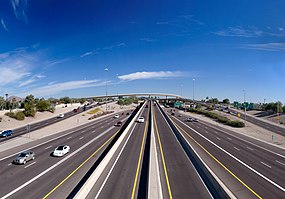
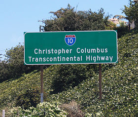
La Interestatal 10 (abreviada I-10) es la autopista del Sistema Interestatal de trazado este-oeste (costa a costa) más al sur de los Estados Unidos. Comienza cerca del océano Pacífico en la Ruta Estatal de California 1 en Santa Mónica, California y recorre 2460 km hasta la Interestatal 95 en Jacksonville, Florida.[2] La autopista conecta a grandes metrópolis como Los Ángeles, Phoenix, Houston y Nueva Orleans.
Largo de la ruta
[editar]| Km. | Estado | ||
| 390.33 | |||
| 631.39 | |||
| 264.37 | |||
| 1418 | |||
| 441.64 | |||
| 124.23 | |||
| 106.72 | |||
| 583 | |||
| 3959 | Total | ||
Ciudades principales
[editar]Las principales ciudades por los que pasa la carretera son:
- California
- Arizona y Nuevo México
- Texas
- Luisiana
- Misisipí y Alabama
- Florida
Mayores cruces
[editar]Los cruces de estas carretera son:
- Interestatal 405 en Oeste de Los Ángeles, California
- Interestatal 110 al suroeste de Downtown Los Angeles, California
- Interestatal 5 en el East Los Angeles Interchange en Los Ángeles, California
- Interestatal 710 en East Los Angeles, California
- Interestatal 605 en El Monte/Baldwin Park, California
- Interestatal 15 en Ontario, California
- Interestatal 215 en San Bernardino, California
- Interestatal 17 en Phoenix, Arizona
- Interestatal 8 en Casa Grande, Arizona
- Interestatal 19 en Tucson, Arizona
- Interestatal 25 en Las Cruces, Nuevo México
- Interestatal 20 cerca de Kent, Texas
- Interestatal 410 en San Antonio, Texas (dos veces)
- Interestatal 35 y Interestatal 37 en San Antonio, Texas
- Interestatal 45 y Interestatal 69 en Houston, Texas
- Interestatal 610 en Houston, Texas (dos veces)
- Interestatal 210 en Lake Charles, Luisiana (dos veces)
- Interestatal 49 en Lafayette, Luisiana
- Interestatal 110 y Interestatal 12 en Baton Rouge, Luisiana
- Interestatal 55 en Laplace, Luisiana
- Interestatal 310 cerca Kenner, Luisiana
- Interestatal 610 (dos veces) y Interestatal 510 en Nueva Orleans, Luisiana
- Interestatal 12 y Interestatal 59 en Slidell, Luisiana
- Interestatal 110 en Biloxi, Misisipi
- Interestatal 65 en Mobile, Alabama
- Interestatal 110 en Pensacola, Florida
- Interestatal 75 en Lake City, Florida
- Interestatal 295 y Interestatal 95 en Jacksonville, Florida
Referencias
[editar]- ↑ «Longitud de la Interestatal 10». Departamento de Transporte de los Estados Unidos. Consultado el 19 de septiembre de 2011.
- ↑ «Lista de extremos y salidas de la Interestatal 10». IHOZ.com. Consultado el 19 de septiembre de 2011.
Enlaces externos
[editar] Wikimedia Commons alberga una categoría multimedia sobre Interestatal 10.
- Lista de ciudades servidas por autopistas interestatales
- Longitud de la Interestatal 10 en Alabama
- Lista de Autopistas por estado en AARoads.com
Text is available under the CC BY-SA 4.0 license; additional terms may apply.
Images, videos and audio are available under their respective licenses.
