Frontera entre Bosnia-Herzegovina y Montenegro
| Frontera entre Bosnia-Herzegovina y Montenegro | ||||
|---|---|---|---|---|
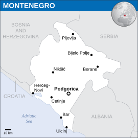
 Mapa general de Montenegro.
| ||||
| Longitud total | 242 km | |||
| Historia | ||||
| Creación | 1991 | |||
| Trazado actual | 2006 | |||
La frontera entre Bosnia-Herzegovina y Montenegro es la frontera internacional terrestre entre Montenegro y Bosnia y Herzegovina. Transcurre en dirección nordeste-sudeste separando los municipios montenegrinos de Pljevlja, Plužine, Nikšić, Kotor y Herceg Novi de la República Serbia de Bosnia y Herzegovina.
Trazado
[editar]Empieza a su extremo septentrional en el trifinio entre ambos estados y Serbia, de los Alpes Dináricos hasta el norte de Sandžak, donde están las cumbres más altas del país, el Volujak (2,336 m) y el Maglić (2368 m), al parque nacional Sutjeska. De allí sigue hacia el suroeste a través del río Trebišnjica hasta las cumbres Orjen y Bijela Gora (Jastrebica, 1862 m) y Bjelotina con el Sitnica (950 metros) a unos ocho kilómetros del trifinio entre Bosnia y Herzegovina-Montenegro-Croacia (en el condado de Dubrovnik-Neretva, donde hay Dubrovnik), casi al litoral del mar Adriático, a la bahía de Kotor.
Historia
[editar]La frontera sigue los antiguos límites administrativos otomanos, y salvo Kotor, después de la ocupación de Bosnia y Herzegovina en 1878 también era la frontera sudeste de Austria-Hungría con el Reino de Montenegro. Ambos territorios se incorporaron al reino de Yugoslavia después de la Primera Guerra Mundial y a la República Federal de Yugoslavia después de la Segunda Guerra Mundial.[1][2] Se convirtió en frontera internacional después de la disolución de Yugoslavia en 1991, inicialmente como parte de la frontera entre Bosnia y Herzegovina y la República Federal de Yugoslavia (después Serbia y Montenegro), y desde 2006 entre Bosnia y Montenegro. Según las conclusiones de la Comisión Badinter, creada a propuesta de la entonces Comunidad Europea y presidida por el juez constitucional francés, Robert Badinter, se declaró como frontera estatal la frontera anterior.[3]
Pasos fronterizos
[editar]
Los principales fronterizos entre los dos países son (primero la parte bosnia):[4]
- Zupci-Sitnica a la carretera Trebinje-Herceg Novi
- Klobuk-Ilino Brdo a la carretera Trebinje-Nikšyć
- Deleuša-Vraćenovićy a la carretera Bileća-Nikšyć
- Hum-Šćepan Polje a la carretera Foča-Nikšyć
- Metaljka a la carretera Goražde-Pljevlja
Referencias
[editar]- ↑ Bosnische Ansprüche auf die Bucht von Kotor. Reportage, Adelheid Wölfl, a: der Standard online, 30. Januar 2015.
- ↑ Vergl. Balkans: Yugoslavia Historical; Bosnia Serbia Montenegro; nationalities 1920 map. A: Harmsworth's new Atlas 1920 (visible a Commons).
- ↑ Westbalkan-Konferenz - Grenzabkommen zwischen Bosnien und Montenegro. Archivado el 20 de julio de 2018 en Wayback Machine. In: Tiroler Tageszeitung online, 23. Augusto 2015.
- ↑ Montenegro: Grenzübergänge. ÖAMTC (Stand: 04/2015, abgerufen 11. März 2015).
Text is available under the CC BY-SA 4.0 license; additional terms may apply.
Images, videos and audio are available under their respective licenses.
