Foreland Norte y Sur
| Foreland Norte y Sur | ||
|---|---|---|
| orth Foreland - South Foreland | ||
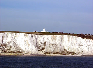
 Acantilados en Foreland Sur | ||
| Ubicación | ||
| Continente | Europa occidental | |
| Mar | Canal de la Mancha (Atlántico) | |
| Archipiélago | Islas británicas | |
| Isla | Isla de Gran Bretaña | |
| País |
| |
| División |
| |
| Subdivisión | Condado de Kent | |
| Coordenadas | 51°22′30″N 1°26′42″E / 51.375, 1.445 | |
| Características | ||
| Tipo | Página de desambiguación de Wikimedia | |
| Mapa de localización | ||
|
Localización en Kent (Foreland Norte) | ||
Foreland Norte (del inglés: North Foreland); TR 39860 69616 51°22′30″N 1°26′42″E / 51.37490, 1.44510 y Foreland Sur (South Foreland; TR 35909 43307 51°08′25″N 1°22′16″E / 51.14040, 1.37110) son dos cabos de creta en la costa oriental de Kent en el sur de Inglaterra (Reino Unido). Foreland Norte forma el extremo oriental de la isla de Thanet; Foreland Sur está a cinco km al noreste del puerto de Dover, sobre el estrecho de Dover y marca el límite suroeste de la bahía de St. Margaret (que recibe este nombre por el pueblo de St Margaret-at-Cliffe). Cada uno presenta un marcado acantilado hacia el mar, y tiene bellas vistas sobre la parte meridional del mar del Norte y el estrecho respectivamente. En Foreland Norte está el faro del mismo nombre, que está automatizado, y en Foreland Sur hay dos: uno que quedó sin servicio en el año 1910 y la luz superior, hoy una propiedad del National Trust, que quedó fuera de servicio en el año 1988.
Foreland Sur es el contrapunto geológico del Cabo Blanc Nez, en la extremidad septentrional del Boulonnais en el departamento francés de Paso de Calais. Los dos son los extremos de tierra del puente terrestre del estrecho de Dover y su estrato geológico de creta dicta la ruta del Eurotúnel. Es por lo tanto el punto más cercano de la tierra principal británica al continente europeo a una distancia de solo 34 km.
Referencias
[editar]Enlaces externos
[editar]- Esta obra contiene una traducción derivada de «North and South Foreland» de Wikipedia en inglés, publicada por sus editores bajo la Licencia de documentación libre de GNU y la Licencia Creative Commons Atribución-CompartirIgual 4.0 Internacional.
- MapServer chart: ubicación de Foreland Norte Archivado el 29 de septiembre de 2007 en Wayback Machine.
- National Trust: ubicación de Foreland Sur
- Fotografía de satélite mostrando el estuario del Támesis
- Fotografías de Foreland Norte y Sur
Text is available under the CC BY-SA 4.0 license; additional terms may apply.
Images, videos and audio are available under their respective licenses.

