Flag (cráter)
| Flag Cráter lunar | ||
|---|---|---|
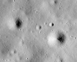
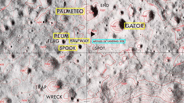
 Imagen desde el Apolo 16, con Flag a la izquierda del centro y Spook a la derecha del centro. Plum es el pequeño cráter en el borde sureste de Flag. | ||
| Coordenadas | 8°58′S 15°27′E / -8.97, 15.45 | |
| Diámetro | 240 m[1] | |
| Profundidad | 20 m | |
| Epónimo | Cráter nombrado por los astronautas (topónimo procedente del Lunar Topophotomap) | |
|
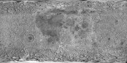
Localización sobre el mapa lunar | ||

Flag es un pequeño cráter lunar situado en las Tierras Altas de Descartes, visitado por los astronautas del Apolo 16. El nombre del cráter fue adoptado formalmente por la Unión Astronómica Internacional en 1973. La Estación 1 de geología[1] está adyacente a Flag, en el cráter Plum, mucho más pequeño.
El módulo lunar Orion del Apolo 16 aterrizó entre los cráteres North Ray y South Ray el 21 de abril de 1972. Los astronautas John Young y Charles M. Duke exploraron el área entre los cráteres en el transcurso de tres EVAs utilizando un Lunar Roving Vehicle o rover. Visitaron Flag en la EVA 1.
El cráter Flag tiene aproximadamente 240 m de diámetro y más de 20 m de profundidad.[2] El cráter adyacente Plum mide solo 30 m de diámetro.[3] El cráter ligeramente más grande Spook, también visitado por los astronautas, se encuentra a menos de 1 km al este .
Flag se inserta en la Formación Cayley del Período Ímbrico.[4]
Véase también
[editar]- Anexo:Cráteres de la Luna
- Selenografía
- Cráter Plum (muestras geológicas)
Referencias
[editar]- ↑ a b Flag, Gazetteer of Planetary Nomenclature, International Astronomical Union (Unión Astronómica Internacional) Working Group for Planetary System Nomenclature (WGPSN)
- ↑ Apollo 16 Landing Area, 78D2S1(50), NASA Lunar Topophotomap. Published by The Defense Mapping Agency, November 1974. Available from Lunar and Planetary Institute.
- ↑ Plum, Gazetteer of Planetary Nomenclature, International Astronomical Union (Unión Astronómica Internacional) Working Group for Planetary System Nomenclature (WGPSN)
- ↑ Geologic Map of the Apollo 16 (Descartes) Landing Area Archivado el 21 de julio de 2019 en Wayback Machine. by Apollo Field Geology Investigation Team (D. P. Elston, E. L. Boudette, J. P. Schafer), Servicio Geológico de los Estados Unidos, April 1972
- (WGPSN), IAU Working Group for Planetary System Nomenclature (13 de febrero de 2013). «Gazetteer of Planetary Nomenclature. 1:1 Million-Scale Maps of the Moon» (en inglés). UAI / USGS. Consultado el 6 de abril de 2016.
- Andersson, L. E.; Whitaker, E. A., (1982). NASA Catalogue of Lunar Nomenclature (en inglés). NASA RP-1097.
- Blue, Jennifer (25 de julio de 2007). «Gazetteer of Planetary Nomenclature» (en inglés). USGS. Consultado el 2 de enero de 2012.
- Bussey, B.; Spudis, P. (2004). The Clementine Atlas of the Moon (en inglés). Nueva York: Cambridge University Press. ISBN 0-521-81528-2.
- Cocks, Elijah E.; Cocks, Josiah C. (1995). Who's Who on the Moon: A Biographical Dictionary of Lunar Nomenclature (en inglés). Tudor Publishers. ISBN 0-936389-27-3.
- McDowell, Jonathan (15 de julio de 2007). «Lunar Nomenclature» (en inglés). Jonathan's Space Report. Consultado el 2 de enero de 2012.
- Menzel, D. H.; Minnaert, M.; Levin, B.; Dollfus, A.; Bell, B. (1971). «Report on Lunar Nomenclature by The Working Group of Commission 17 of the IAU». Space Science Reviews (en inglés) 12: 136.
- Moore, Patrick (2001). On the Moon (en inglés). Sterling Publishing Co. ISBN 0-304-35469-4.
- Price, Fred W. (1988). The Moon Observer's Handbook (en inglés). Cambridge University Press. ISBN 0521335000.
- Rükl, Antonín (1990). Atlas of the Moon (en inglés). Kalmbach Books. ISBN 0-913135-17-8.
- Webb, Rev. T. W. (1962). Celestial Objects for Common Telescopes, 6ª edición revisada (en inglés). Dover. ISBN 0-486-20917-2.
- Whitaker, Ewen A. (2003). Mapping and Naming the Moon (en inglés). Cambridge University Press. 978-0-521-54414-6.
- Wlasuk, Peter T. (2000). Observing the Moon (en inglés). Springer. ISBN 1-85233-193-3.
- «Lunar Impact Crater Database» (en inglés). Lunar and Planetary Institute (USRA). Consultado el 12 de septiembre de 2017.
Enlaces externos
[editar]- Referencia UAI del CRÁTER
- Apollo 16 Traverses, 78D2S2 (25), Lunar and Planetary Institute
- LPI Digital Lunar Orbiter Photographic Atlas of the Moon
- Mapa LROC
- The-moon.wikispaces.com: Flag
 Wikimedia Commons alberga una categoría multimedia sobre Flag.
Text is available under the CC BY-SA 4.0 license; additional terms may apply.
Images, videos and audio are available under their respective licenses.


