Ruta europea E5
| Ruta europea E05 | ||
|---|---|---|
|
Warwickshire, Cumbria, Staffordshire, South Lanarkshire, Dumfries and Galloway y Cheshire, | ||
 | ||
 | ||
| Datos de la ruta | ||
| Identificador |
| |
| Tipo | ruta (clase A) | |
| Longitud | 2960 km | |
| Red | International E-Road network | |
| Orientación | ||
| • Norte | Greenock (Reino Unido) | |
| • Sur | Algeciras (España) | |
| Lugares | ||
| Lugares que atraviesa | Greenock, Glasgow, Preston, Birmingham, Southampton, Le Havre, París, Orleans, Burdeos, San Sebastián, Burgos, Madrid, Córdoba, Sevilla, Algeciras | |
La E-05 o E5 forma parte de la Red de Carreteras Europeas, concretamente de las carreteras de recorrido Norte-Sur, inicia su recorrido en la ciudad de Greenock (Gran Bretaña), recorre Reino Unido, Francia y España hasta finalizar su recorrido en Algeciras (Cádiz).[1] Su longitud es de 2960 km.
Tramos
[editar]En Reino Unido
[editar]| Carretera | Inicio | Fin |
|---|---|---|
| A8 |
Greenock | |
| A8 |
Greenock | Govan, Glasgow |
| Glasgow | Glasgow | |
| A74 |
Glasgow | Carlisle |
| Carlisle | Birmingham | |
| Carlisle | Birmingham | |
| Birmingham mediante Newbury | Southampton |
| Carretera | Inicio | Fin |
|---|---|---|
| N 182 | Le Havre | A 131 |
| Le Havre | Bourneville | |
| Bourneville | París | |
| París | Wissous | |
| Wissous | Orleáns | |
| Orleáns | Tours | |
| Tours | Poitiers | |
| Poitiers | Burdeos | |
| N 10 |
Burdeos | Hendaya |
| Carretera | Inicio | Fin |
|---|---|---|
| Irún | Éibar | |
| Éibar | Vitoria | |
| N-622 | Vitoria | |
| Vitoria | Armiñón | |
| Armiñón | Burgos | |
| Burgos | Madrid | |
| Madrid | ||
| Madrid | Sevilla | |
| Dos Hermanas | La Rinconada | |
| Sevilla | Dos Hermanas | |
| Dos Hermanas | Puerto Real | |
| Puerto Real | Vejer de la Frontera | |
| N-340 | Vejer de la Frontera | Algeciras |
| Algeciras | Enlace con la N-357 |
Galería
[editar]-
 M3 a su paso por Southampton
 -
 E05 por Francia
 -
 A-4 a la salida de Manzanares
 -
 Panel de confirmación A-48
 -
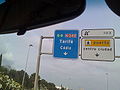 E-5 por N-340 (Entrada a A-7) en Algeciras
 -
 Identificador para la E-05 usado en España.
 -
 Identificador para la E-05 usado en Francia.


_a_la_salida_de_Manzanares.jpg)


Véase también
[editar]Referencias
[editar]- ↑ UNECE (26 de octubre de 2016). «European Agreement on Main International Traffic Arteries» (en inglés). p. 11. Consultado el 14 de agosto de 2021.
Enlaces externos
[editar]Text is available under the CC BY-SA 4.0 license; additional terms may apply.
Images, videos and audio are available under their respective licenses.
Cover photo is available under {{::mainImage.info.license.name || 'Unknown'}} license.
Cover photo is available under {{::mainImage.info.license.name || 'Unknown'}} license.
Credit:
(see original file).
