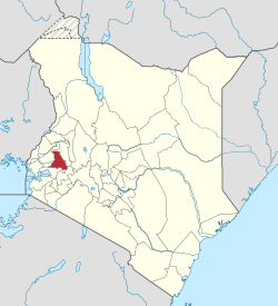
Condado de Nandi
| Condado de Nandi | ||
|---|---|---|
| Condado | ||
 | ||
| Coordenadas | 0°10′00″N 35°09′00″E / 0.16666666666667, 35.15 | |
| Capital | Kapsabet | |
| Entidad | Condado | |
| • País | Kenia | |
| Superficie | ||
| • Total | 2884,5 km² | |
| Población | ||
| • Total | 578,751 hab. | |
| • Densidad | 307,06 hab./km² | |
| Huso horario | Tiempo de África Oriental | |
| Sitio web oficial | ||
El condado de Nandi es un condado de Kenia, que antes de la reforma de 2013 fue un distrito de la antigua provincia del Valle del Rift. Cuenta con una población de 578 751 habitantes según el censo de 2009, la mayor parte pertenecen a la tribu Nandi. Su capital es Kapsabet y el principal accidente geográfico son las colinas de Nandi.
El condado de Nandi es famoso por ser el lugar de nacimiento de numerosos corredores de élite de larga distancia, entre ellos Rodgers Rop, Bernard Lagat, Robert Kipkoech Cheruiyot, Peter Rono, Wilfred Bungei, Pamela Jelimo, Martin Lel, Kipchoge Keino, Henry Rono, Moses Tanui, Eliud Kipchoge y Bernard Lagat.[1]
Localización
[editar]El condado tiene los siguientes límites:[2]
| Noroeste: Condado de Kakamega | Norte: Condado de Uasin Gishu | Noreste: Condado de Uasin Gishu |
| Oeste: Condado de Vihiga | 
|
Este: Condado de Uasin Gishu |
| Suroeste: Condado de Kisumu | Sur: Condado de Kisumu | Sureste: Condado de Kericho |
Demografía
[editar]Las principales localidades del condado son:[3]
- Kapsabet, municipio, 91 030 habitantes
- Nandi Hills, villa, 73 626 habitantes
División administrativa
[editar]| División | Población | Población urbana | Capital |
|---|---|---|---|
| Aldai | 96.220 | 200 | Kobujoi |
| Kabiyet | 43.367 | 751 | Kabiyet |
| Kapsabet | 125.115 | 16.942 | Kapsabet |
| Kaptumo | 26.782 | 150 | Kaptumo |
| Kilibwoni | 62.692 | 116 | Kilibwoni |
| Kipkaren | 52,753 | 0 | |
| Kosirai | 35.383 | 957 | |
| Nandi Hills | 77.514 | 3499 | Nandi Hills |
| Tinderet | 58.925 | 0 |
Transportes
[editar]La principal carretera del condado es la C39, que une Eldoret con el condado de Vihiga pasando por Chepterit y Kapsabet. Al este de Kapsabet sale de la C39 la C36, que lleva a la A104 unos kilómetros al sur de Burnt Forest. Al noroeste de Chepterit sale de la C39 la C37, que lleva a Turbo.[4]
Referencias
[editar]- ↑ Kenya, openData. Archivado el 6 de junio de 2012 en Wayback Machine. Consultado el 16 de agosto de 2012
- ↑ Statistical abstract 2013 (en inglés). Kenya National Bureau of Statistics (KNBS). 2013. pp. iv, 8. ISBN 9966-767-45-2.
- ↑ «Copia archivada». Archivado desde el original el 29 de julio de 2016. Consultado el 28 de julio de 2016. 2009 Census Vol 1 Table 3 Rural and Urban Population Retrieved on 22 January 2014.
- ↑ Mapa del Condado de Nandi en Google Maps
Enlaces externos
[editar] Wikimedia Commons alberga una categoría multimedia sobre Condado de Nandi.
 Condado de Nandi en OpenStreetMap.
Text is available under the CC BY-SA 4.0 license; additional terms may apply.
Images, videos and audio are available under their respective licenses.
