Condado de Clarion
| Condado de Clarion | ||
|---|---|---|
| Condado | ||
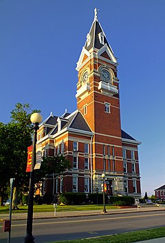
 Palacio de Justicia del Condado de Clarion | ||
 | ||
| Coordenadas | 41°11′N 79°25′O / 41.19, -79.42 | |
| Capital | Clarion | |
| Ciudad más poblada | Clarion | |
| Entidad | Condado | |
| • País |
| |
| • Estado |
| |
| • Sede | Clarion | |
| Fundación | 11 de marzo de 1839 | |
| Superficie | ||
| • Total | 1577 km² | |
| • Tierra | 1.559 km² | |
| • Agua | (1.07%) 18 km² | |
| Población (2000) | ||
| • Total | 41,765 hab. | |
| • Densidad | 27 hab./km² | |
| Huso horario | Este: UTC-5 | |
| • en verano | UTC-4 | |
| Sitio web oficial | ||
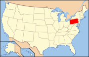
El condado de Clarion (en inglés: Clarion County), fundado en 1839, es uno de 67 condados del estado estadounidense de Pensilvania. En el año 2000 tenía una población de 41.765 habitantes con una densidad poblacional de 27 personas por km². La sede del condado es Clarion.[1]
Geografía
[editar]Según la Oficina del Censo, el condado tiene un área total de 1577 km² (608,9 mi²), de la cual 1559 km² (601,9 mi²) es tierra y 18 km² (6,9 mi²) (1.07%) es agua.
Condados
[editar]- Condado de Forest (norte)
- Condado de Jefferson (este)
- Condado de Armstrong (sur)
- Condado de Butler (suroeste)
- Condado de Venango (oeste)
Demografía
[editar]Según el censo de 2000,[2] había 41,765 personas, 16,052 hogares y 10,738 familias residiendo en la localidad. La densidad de población era de 27 hab./km². Había 19,426 viviendas con una densidad media de 12 viviendas/km². El 98.16% de los habitantes eran blancos, el 0.79% afroamericanos, el 0.11% amerindios, el 0.34% asiáticos, el 0.00% isleños del Pacífico, el 0.08% de otras razas y el 0.52% pertenecía a dos o más razas. El 4.96% de la población eran hispanos o latinos de cualquier raza.
Localidades
[editar]Boroughs
[editar]Callensburg | Clarion | East Brady | Emlenton‡ | Foxburg | Hawthorn | Knox | New Bethlehem | Rimersburg | Shippenville | Sligo | St. Petersburg | Strattanville
Municipios
[editar]Ashland | Beaver | Brady | Clarion | Elk | Farmington | Highland | Knox | Licking | Limestone | Madison | Millcreek | Monroe | Paint | Perry | Piney | Porter | Redbank | Richland | Salem | Toby | Washington
Lugares designados por el censo
[editar]Crown | Leeper | Marianne | Vowinckel
Áreas no incorporadas
[editar]Referencias
[editar]- ↑ «Encuentra un condado» (en inglés). Asociación Nacional de Condados. 2 de mayo de 2013. Consultado el 2 de mayo de 2013.
- ↑ «American FactFinder» (en inglés). Oficina del Censo de los Estados Unidos. Consultado el 2 de mayo de 2013.
Enlaces externos
[editar] Portal:Pensilvania. Contenido relacionado con Pensilvania.
 Wikimedia Commons alberga una categoría multimedia sobre Condado de Clarion.
- Condado de Clarion (sitio oficial)
Text is available under the CC BY-SA 4.0 license; additional terms may apply.
Images, videos and audio are available under their respective licenses.

