Brunico
| Brunico (Bruneck) | ||
|---|---|---|
| Entidad subnacional | ||
 | ||
 Escudo | ||
 Brunico (Bruneck) Localización de Brunico (Bruneck) en Trentino-Tirol del Sur | ||
 Brunico (Bruneck) Localización de Brunico (Bruneck) en Italia | ||
| Coordenadas | 46°47′47″N 11°56′08″E / 46.796319, 11.935512 | |
| Idioma oficial | Alemán e italiano | |
| Entidad | Comuna de Italia | |
| • País | Italia | |
| • Región | Trentino-Alto Adigio | |
| • Provincia | Bolzano | |
| Fracciones | Villa Santa Caterina (Aufhofen), Teodone (Dietenheim), Riscone (Reischach), Stegona (Stegen), Lunes (Luns), San Giorgio (St. Georgen) | |
| Municipios limítrofes | Falzes, Gais, Marebbe, Perca, Rasun Anterselva, San Lorenzo di Sebato, Valdaora | |
| Superficie | ||
| • Total | 45 km² | |
| Altitud | ||
| • Media | 838 m s. n. m. | |
| Población (31-12-20) | ||
| • Total | 17,050 hab. | |
| • Densidad | 374,58 hab./km² | |
| Gentilicio | Brunicensi | |
| Huso horario | CET (UTC +1) | |
| • en verano | CEST (UTC +2) | |
| Código postal | 39031[1] | |
| Prefijo telefónico | 0474 | |
| Matrícula | BZ | |
| Código ISTAT | 021013 | |
| Código catastral | B220[2] | |
| Sitio web oficial | ||
 Vista de Brunico
| ||
Brunico (en italiano) o Bruneck (en alemán) es un municipio de 17 050 (2020) habitantes perteneciente a la Provincia Autónoma de Bolzano (Bozen), Italia. El 80% de la población tiene como lengua materna el alemán. Es la capital histórica, cultural, económica y administrativa de la Val Pusteria (Pustertal).
Se encuentra atravesada por el río Rienza (Rienz).
Dista unos 35 km de Bresanona (Brixen), 70 km de Bolzano (Bozen) y del Brennero (Brenner, frontera austríaca) y cerca de 35 km de Prato alla Drava (Winnebach) (frontera austríaca).
Al sur se encuentra la localidad de esquí Plan de Corones (Kronplatz) (2273 m s. n. m.), al noreste la Croda Nera (3105 m s. n. m.) y al noroeste el Monte Sommo (2417 m s. n. m.).
Comprensorio de la Val Pusteria.
Entre los valles más cercanos a Brunico podemos citar: Val di Tures (o bien Valle Aurina), Val Badia, Valle di Anterselva.
Nativos célebres
[editar]- Nanni Moretti (1953-), director de cine.
- Dorothea Wierer (1990-), deportista de biatlón.
- La banda de Black metal sinfónico Graveworm fue fundada en Brunico en 1992.
Evolución demográfica
[editar]| Gráfica de evolución demográfica de Brunico entre 1921 y 2001 |
 |
|
Fuente: Istituto Nazionale di Statistica - Elaboración gráfica por Wikipedia |
-
 Localización de Brunico en la Provincia de Bolzano.
 -
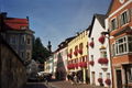 Calle de Brunico.
 -
 Puerta: der Urselinentor.
 -
 Passeggiata Tielt.


Ciudades hermanadas
[editar]Referencias
[editar]- ↑ Worldpostalcodes.org, código postal n.º 39031.
- ↑ «Codici Catastali». Comuni-italiani.it (en italiano). Consultado el 29 de abril de 2017.
Enlaces externos
[editar] Wikimedia Commons alberga una galería multimedia sobre Brunico.
Text is available under the CC BY-SA 4.0 license; additional terms may apply.
Images, videos and audio are available under their respective licenses.
