For faster navigation, this Iframe is preloading the Wikiwand page for Archivo:Carta Hydrographica y Chorographica de la Yslas Filipinas MANILA, 1734.jpg.

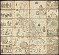
Archivo:Carta Hydrographica y Chorographica de la Yslas Filipinas MANILA, 1734.jpg

Ver la imagen en su resolución original(2000 × 1870 píxeles; tamaño de archivo: 2,09 MB; tipo MIME: image/jpeg)

Este es un archivo de Wikimedia Commons, un depósito de contenido libre hospedado por la Fundación Wikimedia. Más abajo se reproduce su página de descripción con la información sobre su origen y licencia.

Resumen

Descripción
English: This magnificent map of the Philippine archipelago, drawn by the Jesuit Father Pedro Murillo Velarde (1696–1753) and published in Manila in 1734, is the first and most important scientific map of the Philippines. The Philippines were at that time a vital part of the Spanish Empire, and the map shows the maritime routes from Manila to Spain and to New Spain (Mexico and other Spanish territory in the New World), with captions. In the upper margin stands a great cartouche with the title of the map, crowned by the Spanish royal coat of arms flanked each side by an angel with a trumpet, from which an inscription unfurls. The map is not only of great interest from the geographic point of view, but also as an ethnographic document. It is flanked by twelve engravings, six on each side, eight of which depict different ethnic groups living in the archipelago and four of which are cartographic descriptions of particular cities or islands. According to the labels, the engravings on the left show: Sangleyes (Chinese Philippinos) or Chinese; Kaffirs (a derogatory term for non-Muslims), a Camarin (from the Manila area), and a Lascar (from the Indian subcontinent, a British Raj term); mestizos, a Mardica (of Portuguese extraction), and a Japanese; and two local maps—one of Samboagan (a city on Mindanao), and the other of the port of Cavite. On the right side are: various people in typical dress; three men seated, an Armenian, a Mughal, and a Malabar (from an Indian textile city); an urban scene with various peoples; a rural scene with representations of domestic and wild animals; a map of the island of Guajan (meaning Guam); and a map of Manila. Ethnic groups; Nautical charts
Fecha
Fuente https://www.wdl.org/en/item/10089/
Autor

Cartographer: Murillo Velarde, Pedro, 1696-1753

Engraver: Bagay, Nicolás de la Cruz, 1701-1771

Licencia

Public domain

Este material está en dominio público en los demás países donde el derecho de autor se extiende por 50 años (o menos) tras la muerte del autor.


Esta obra está en el dominio público en los Estados Unidos porque fue publicada (o registrada con la Oficina del Derecho de Autor de los E.E. U.U.) antes del 1 de enero de 1929.

Leyendas

Añade una explicación corta acerca de lo que representa este archivo

Elementos representados en este archivo

representa a

image/jpeg

ddf35612dc4eca097b61a3712e584ad2f2441156

2 189 744 byte

1870 píxel

2000 píxel

Historial del archivo

Haz clic sobre una fecha y hora para ver el archivo tal como apareció en ese momento.

Fecha y horaMiniaturaDimensionesUsuarioComentario
actual18:23 9 nov 2018Miniatura de la versión del 18:23 9 nov 20182000 × 1870 (2,09 MB)Obsidian SoulUser created page with UploadWizard

Usos del archivo

Uso global del archivo

Las wikis siguientes utilizan este archivo:

{{bottomLinkPreText}} {{bottomLinkText}}
Archivo:Carta Hydrographica y Chorographica de la Yslas Filipinas MANILA, 1734.jpg
Listen to this article

This browser is not supported by Wikiwand :(
Wikiwand requires a browser with modern capabilities in order to provide you with the best reading experience.
Please download and use one of the following browsers:

This article was just edited, click to reload
This article has been deleted on Wikipedia (Why?)

Back to homepage

Please click Add in the dialog above
Please click Allow in the top-left corner,
then click Install Now in the dialog
Please click Open in the download dialog,
then click Install
Please click the "Downloads" icon in the Safari toolbar, open the first download in the list,
then click Install
{{::$root.activation.text}}

Install Wikiwand

Install on Chrome Install on Firefox
Don't forget to rate us

Tell your friends about Wikiwand!

Gmail Facebook Twitter Link

Enjoying Wikiwand?

Tell your friends and spread the love:
Share on Gmail Share on Facebook Share on Twitter Share on Buffer

Our magic isn't perfect

You can help our automatic cover photo selection by reporting an unsuitable photo.

This photo is visually disturbing This photo is not a good choice

Thank you for helping!


Your input will affect cover photo selection, along with input from other users.

X

Get ready for Wikiwand 2.0 🎉! the new version arrives on September 1st! Don't want to wait?