Almanon (cráter)
| Almanon Cráter lunar | ||
|---|---|---|
 Mosaico de imágenes LRO | ||
| Coordenadas | 16°51′S 15°08′E / -16.85, 15.14 | |
| Diámetro | 49 km | |
| Profundidad | 2.5 km | |
| Colongitud | 345° al amanecer | |
| Epónimo | Al-Mamún (califa) | |
|
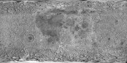
Localización sobre el mapa lunar | ||


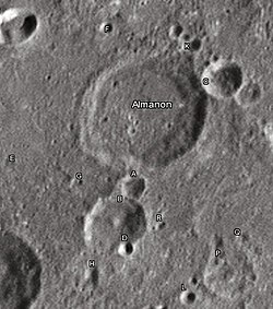
Almanon es un cráter de impacto situado en las escarpadas tierras altas de la región sur-central de la Luna. Se encuentra al sur-sureste del cráter Abulfeda y al nor-noreste del cráter Geber. La cadena de cráteres denominada Catena Abulfeda forma una línea desde el borde sur de Abulfeda hasta el borde norte de Almanon, y continúa otros 210 kilómetros hasta el escarpe de Rupes Altai.
El borde de Almanon tiene forma de círculo ligeramente deformado, con protuberancias hacia el exterior al norte y al suroeste. Los cráteres satélite Almanon A y Almanon B se encuentran unidos al exterior del borde meridional. La pared interior es más ancha a lo largo del lado oriental que en el resto del perímetro. Cráteres pequeños, que pertenecen a la Catena Abulfeda, invaden ligeramente el borde noreste. En general, la pared exterior está desgastada y carece de la nitidez de otros cráteres más recientes, aunque no se ha visto afectada de manera significativa por la formación de cráteres posteriores. La superficie interior es relativamente plana y no posee características notables aparte de unos pequeños cráteres.
Fue llamado así en memoria del califa abásida Al Ma-mún
Cráteres satélite
[editar]Por convención estos elementos son identificados en los mapas lunares poniendo la letra en el lado del punto medio del cráter que está más cercano a Almanon.
 |
|
Véase también
[editar]Referencias
[editar]- (WGPSN), IAU Working Group for Planetary System Nomenclature (13 de febrero de 2013). «Gazetteer of Planetary Nomenclature. 1:1 Million-Scale Maps of the Moon» (en inglés). UAI / USGS. Consultado el 6 de abril de 2016.
- Andersson, L. E.; Whitaker, E. A., (1982). NASA Catalogue of Lunar Nomenclature (en inglés). NASA RP-1097.
- Blue, Jennifer (25 de julio de 2007). «Gazetteer of Planetary Nomenclature» (en inglés). USGS. Consultado el 2 de enero de 2012.
- Bussey, B.; Spudis, P. (2004). The Clementine Atlas of the Moon (en inglés). Nueva York: Cambridge University Press. ISBN 0-521-81528-2.
- Cocks, Elijah E.; Cocks, Josiah C. (1995). Who's Who on the Moon: A Biographical Dictionary of Lunar Nomenclature (en inglés). Tudor Publishers. ISBN 0-936389-27-3.
- McDowell, Jonathan (15 de julio de 2007). «Lunar Nomenclature» (en inglés). Jonathan's Space Report. Consultado el 2 de enero de 2012.
- Menzel, D. H.; Minnaert, M.; Levin, B.; Dollfus, A.; Bell, B. (1971). «Report on Lunar Nomenclature by The Working Group of Commission 17 of the IAU». Space Science Reviews (en inglés) 12: 136.
- Moore, Patrick (2001). On the Moon (en inglés). Sterling Publishing Co. ISBN 0-304-35469-4.
- Price, Fred W. (1988). The Moon Observer's Handbook (en inglés). Cambridge University Press. ISBN 0521335000.
- Rükl, Antonín (1990). Atlas of the Moon (en inglés). Kalmbach Books. ISBN 0-913135-17-8.
- Webb, Rev. T. W. (1962). Celestial Objects for Common Telescopes, 6ª edición revisada (en inglés). Dover. ISBN 0-486-20917-2.
- Whitaker, Ewen A. (2003). Mapping and Naming the Moon (en inglés). Cambridge University Press. 978-0-521-54414-6.
- Wlasuk, Peter T. (2000). Observing the Moon (en inglés). Springer. ISBN 1-85233-193-3.
- «Lunar Impact Crater Database» (en inglés). Lunar and Planetary Institute (USRA). Consultado el 12 de septiembre de 2017.
Enlaces externos
[editar]- Referencia UAI del CRÁTER
- LPI Digital Lunar Orbiter Photographic Atlas of the Moon
- Mapa LROC
- The-moon.wikispaces.com: Almanon Archivado el 15 de abril de 2009 en Wayback Machine.
 Wikimedia Commons alberga una categoría multimedia sobre Almanon.
Text is available under the CC BY-SA 4.0 license; additional terms may apply.
Images, videos and audio are available under their respective licenses.


