Dosiero:Mapa dos caminhos de ferro em Portugal 1895 - Rede do Minho.jpg
Grandeco de ĉi antaŭvido: 438 × 599 rastrumeroj. Aliaj distingivoj: 175 × 240 rastrumeroj | 512 × 700 rastrumeroj.
Bildo en pli alta difino ((512 × 700 rastrumeroj, grandeco de dosiero: 373 KB, MIME-tipo: image/jpeg))
| Jen dosiero de la Wikimedia-Komunejo. La priskribo en ties priskriba paĝo estas montrata suben.
|
Resumo
| Priskribo |
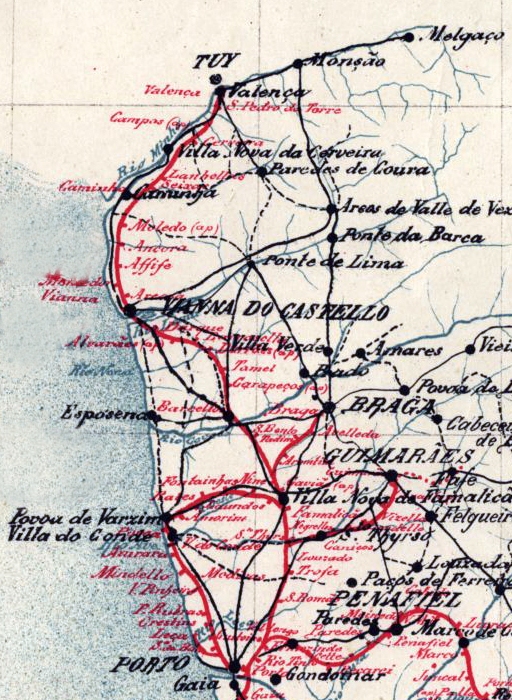
English: Map of the railway network at the Minho and Douro Litoral regions, in northen Portugal, in 1895. The main axis was the Linha do Minho (Minho Railway), in iberian gauge, connecting the city of Porto to the border town of Valença, with a spur to Braga. There was also a network of narrow gauge lines, connecting the city of Porto to Póvoa de Varzim, Guimarães and Famalicão. Português: Mapa da rede ferroviária nas antigas regiões portuguesas do Minho e Douro Litoral, em 1895. A espinha dorsal deste sistema era a Linha do Minho, de bitola ibérica, que ligava o Porto a Valença, com um ramal para Braga. Existia também uma rede ferroviária secundária, de bitola métrica, unindo o Porto a Guimarães, Póvoa de Varzim e Famalicão. |
| Dato | (UTC) |
| Fonto |
Tiu ĉi dosiero estas derivita de: Mapa dos caminhos de ferro em Portugal 1895.jpg:  |
| Aŭtoro |
|
| Ĉi tio estas modifita bildo, kio signifas, ke ĝi ekestis per cifereca aliigo de la origina versio. Modifoj: Isolated the Minho and Douro Litoral regions. La originaĵo videblas ĉi tie: Mapa dos caminhos de ferro em Portugal 1895.jpg. La modifojn faris Ajpvalente.
|
Permesiloj:
|
Tiu ĉi verko estas publika havaĵo en tiuj landoj, kies kopirajtado validas por longo de vivo plus 70 jaroj aŭ malpli. This work is in the public domain in the United States because it was published (or registered with the U.S. Copyright Office) before January 1, 1929. | |
| Estis konkludite ke uzon de ĉi tiu dosiero limigas neniu konata aŭtorrajta leĝo, kio inkluzivas ĉiujn rilatajn kaj apudajn rajtojn. | |
Originala alŝutada protokolo
This image is a derivative work of the following images:
- File:Mapa dos caminhos de ferro em Portugal 1895.jpg licensed with PD-old-70-expired
- 2015-08-30T17:29:23Z Polyethylen 2382x3892 (8926900 Bytes) User created page with UploadWizard
Uploaded with derivativeFX
Dosierhistorio
Alklaku iun daton kaj horon por vidi kiel la dosiero tiam aspektis.
| Dato/Horo | Bildeto | Grandecoj | Uzanto | Komento | |
|---|---|---|---|---|---|
| nun | 13:33, 12 sep. 2020 | | 512 × 700 (373 KB) | Ajpvalente | == ((int:filedesc)) == ((Information |Description=((en|1=Map of the railway network at the Minho and Douro Litoral regions, in northen Portugal, in 1895. The main axis was the Linha do Minho (Minho Railway), in iberian gauge, connecting the city of Porto to the border town of Valença, with a spur to Braga. There was also a network of narrow gauge lines, connecting the city of Porto to Póvoa de Varzim, Guimarães and Famalicão.))((pt|1=Mapa da rede ferroviária nas antigas regiões portuguesas do... |
Dosiera uzado
La jena paĝo ligas al ĉi tiu dosiero:
Suma uzado de la dosiero
La jenaj aliaj vikioj utiligas ĉi tiun dosieron:
Text is available under the CC BY-SA 4.0 license; additional terms may apply.
Images, videos and audio are available under their respective licenses.
Cover photo is available under {{::mainImage.info.license.name || 'Unknown'}} license.
Cover photo is available under {{::mainImage.info.license.name || 'Unknown'}} license.
Credit:
(see original file).
