仰光
| 仰光 ရန်ကုန် | |
|---|---|
| Yañḵouñ | |
 | |
| 格言:Yangon Purum Manaw Ra Man | |
 仰光 仰光在緬甸的位置 | |
| 坐标:16°47′42″N 96°09′36″E / 16.795°N 96.16°E | |
| 所屬國家 | |
| 所屬省份 | 仰光省 |
| 建立 | 公元6世紀 |
| 政府 | |
| • 市長 | Hla Myint(2011年起) |
| 面积[1] | |
| • 总计 | 231.18 平方英里(598.75 平方公里) |
| 人口(2014年)[2] | |
| • 總計 | 7,355,075人 |
| • 民族構成 | 緬族、孟族、克倫族、緬甸華人、印裔緬甸人、緬甸歐洲人 |
| • 宗教 | 佛教、基督教、伊斯蘭教 |
| 时区 | MST(UTC+6:30) |
| 電話區號 | 1, 80, 99 |
| 網站 | http://www.yangon.gov.mm/ |

仰光(緬甸語:ရန်ကုန်,緬甸語發音:[jàɰ̃ɡòʊɰ̃] ,Yañḵouñ,缅甸语委转写:ran-kun),原稱大光(孟語:လဂုင် la.gung;緬甸語:ဒဂုံ Dăgouñ,缅甸语委转写:da.guN),為緬甸最大城市也是仰光省首府,原為緬甸首都(2005年11月6日遷至內比都),[3]人口约735万(2014年統計),面積為312平方英里,位於仰光河河岸,伊洛瓦底江三角洲。仰光位於北緯16°48',東經96°9',而其時區是協調世界時加上六個半小時。主要出口有米、柚木、石油、棉花和各類金屬礦藏等。與其他東南亞的大城市比較,仰光相對地不太繁榮,不過市內建築迅速發展,大多數都是外資注入發展的(如中國、新加坡、日本,韓國等國)。市內的下城區及大仰光地區有很多連鎖住宅和商業樓宇被重建或改建。現在仰光擁有東南亞最多的前殖民地建築。在殖民地建築內的政府部分(例如高等法院、市政廳、昂山將軍市場和公立醫院)也被列入重建項目。新城區和其他近郊的地區仍屬貧窮地區。
歷史
地名由來
1753年,雍籍牙國王建都以前,仰光只是小漁村。仰光原名為「大光」(ဒဂုံ မြို့နယ်),於1755年改名为仰光。「仰光」(緬甸語:ရန်ကုန်)是兩個字「ရန်(yan)」和「ကုန်(gon)」的結合,分別指“敵人”和“結束”, 也是“和平” 的意思。
早期歷史
仰光於 11 世紀初(約 1028-1043 年)由當時居住在下緬甸的孟族建立,當時名為大光。[4]從 14 世紀勃固王朝時期開始,大光就成為一個重要的朝聖城鎮。大光的著名統治者包括從 1364 年至 1392 年統治該鎮的瑪哈德威公主[5]和她的侄孫女信紹布,後者後來成為緬甸歷史上唯一一位女王。[6][7]
1755年,貢榜王朝的開國君主雍笈牙攻占了大光,擴張了城市的規模,並將大光改名為「仰光」。大約在1790年代左右,東印度公司在仰光開設了一家工廠。1823 年仰光的人口估計約為 30,000 人左右。[8]英國在第一次英緬戰爭期間佔領了仰光,但戰後將該城市歸還給緬甸統治。該城後於1841年毀於一場大火。[9]
殖民時期(1852—1948)
1852年,英國在第二次英緬戰爭中佔領了仰光和整個下緬甸,隨後將仰光轉變為英屬緬甸的商業和政治中心。戰後,英國人將英屬緬甸的首都從曼德勒遷至仰光。[10][11]根據當時陸軍工程師亞歷山大·弗雷澤中尉(Lt. Alexander Fraser)的設計,英國人計畫在三角洲上建造一座棋盤狀城市,東面緊鄰帕尊當溪,西南邊則緊鄰仰光河。1885年,在英國於第三次英緬戰爭佔領上緬甸後,仰光成為整個英屬緬甸的首都。到了 1890 年代,仰光不斷增長的人口和日漸發達的商業活動,使得城市北邊臨皇家湖和茵雅湖的地方出現了大量郊區住宅區。[12]英國人還建立了仰光總醫院和仰光大學。

仰光也是1857年印度起義後,英國人將蒙兀兒帝國末代皇帝巴哈杜爾·沙二世流放的地方。[13]
殖民時期的仰光擁有面積廣大的公園和湖泊,城市裡新建的現代建築與傳統木造建築互相輝映,因此被譽為「東方花園城市」。[12]到20世紀初,仰光的公共服務和基礎建設能與倫敦相媲美。[14]到了二戰前夕,仰光50萬人口中約有55%是印度人或南亞裔,只有約三分之一是緬人。[15]其他族群則有克倫族、中國人、英緬混血兒等。[來源請求]

第一次世界大戰後,仰光成為緬甸獨立運動的中心,主要由仰光大學的左翼學生領導這場運動。1920年、1936年和1938年三次反對英國統治的全國性罷工都是先從仰光開始的。1930年5月5日,缅甸的勃固地区发生了一场規模7.0的地震,虽当时仰光的人口只有40万,但也导致了仰光有50人丧生[16],同年初还发生了1930年仰光骚乱。

二戰爆發後,日軍於1942年3月8日占領仰光,仰光也在戰爭期間遭受嚴重破壞。1945年5月,盟軍收復仰光。1948年1月4日,緬甸獨立,仰光成為緬甸聯邦的首都。[17]
獨立後
地理及氣候
仰光位於下緬甸,属热带季风气候,终年绿树成荫、鲜花常开,有“花园城市”之称。市区有两个风景秀丽的湖泊——大湖和茵雅湖,市内有举世闻名的仰光大金寺。
| 仰光(1961至1990) | |||||||||||||
|---|---|---|---|---|---|---|---|---|---|---|---|---|---|
| 月份 | 1月 | 2月 | 3月 | 4月 | 5月 | 6月 | 7月 | 8月 | 9月 | 10月 | 11月 | 12月 | 全年 |
| 平均高温 °C(°F) | 32.2 (90.0) |
34.5 (94.1) |
36.0 (96.8) |
37.0 (98.6) |
33.4 (92.1) |
30.2 (86.4) |
29.7 (85.5) |
29.6 (85.3) |
30.4 (86.7) |
31.5 (88.7) |
32.0 (89.6) |
31.5 (88.7) |
32.3 (90.1) |
| 平均低温 °C(°F) | 17.9 (64.2) |
19.3 (66.7) |
21.6 (70.9) |
24.3 (75.7) |
25.0 (77.0) |
24.5 (76.1) |
24.1 (75.4) |
24.1 (75.4) |
24.2 (75.6) |
24.2 (75.6) |
22.4 (72.3) |
19.0 (66.2) |
22.6 (72.7) |
| 平均降雨量 mm(英寸) | 5 (0.2) |
2 (0.1) |
7 (0.3) |
15 (0.6) |
303 (11.9) |
547 (21.5) |
559 (22.0) |
602 (23.7) |
368 (14.5) |
206 (8.1) |
60 (2.4) |
7 (0.3) |
2,681 (105.6) |
| 平均降雨天数 | .2 | .2 | .4 | 1.6 | 12.6 | 25.3 | 26.2 | 26.1 | 19.5 | 12.2 | 4.8 | .2 | 129.3 |
| 数据来源:世界气象组织 [18] | |||||||||||||
交通
航空
仰光國際機場,距离市中心12km,是缅甸的重要门户。拥有众多航班飞往亚洲各主要城市如河内、香港、東京、首爾、廣州、桃園、胡志明市、曼谷、科伦坡和新加坡。 國內航班飛往城市有曼德勒、奈比都、黑河、大其力、實兌、丹兌、土瓦、實皆、娘烏。
-
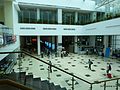 仰光國際機場內部

鐵路
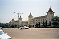
仰光中央車站是緬甸總長5403公里鐵路網中的主要始發站[19],其覆蓋範圍涵蓋緬甸北部地區(內比都、曼德勒、瑞波)、內陸地區(密支那)、撣山丘陵(東枝、臘戍)和德林達依海岸(毛淡棉、土瓦)。
仰光環狀線是一個全長45.9公里,設有 39 個車站的通勤鐵路線,連接仰光市區與周遭的衛星城鎮。其廣受當地民眾歡迎,日運量約150,000人次。[20]
2017年,日本政府提供了超過2億美元的資金,協助提升仰光環狀線的發展、線路維護、購買新車廂及升級信號等計畫。[21][22]
-
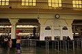 仰光中央车站售票處
 -
.jpg)

教育
高等教育
姐妹城市
圖集
-
 仰光下城區
仰光下城區 -

-
 仰光大金寺的钟
 -

-
 仰光市政廳
仰光市政廳 -

-
 唐人街
唐人街 -
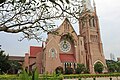 聖三一大教堂


参考
- ^ Third Regional EST Forum: Presentation of Myanmar (PDF). Singapore: Ministry of Transport, Myanmar. 17–19 March 2008 [2010-05-16]. (原始内容存档 (PDF)于2009-02-26).
- ^ United Nations World Urbanization Prospects, 2007 revision. Esa.un.org. [2014-08]. (原始内容存档于2007-07-31).
- ^ Burma's new capital stages parade. BBC News. 27 March 2006 [3 August 2006]. (原始内容存档于2018-12-26).
- ^ Founded during the reign of King Pontarika, per Charles James Forbes Smith-Forbes. Legendary History of Burma and Arakan. The Government Press. 1882: 20.;the king's reign was 1028 to 1043 per Harvey, G. E. History of Burma: From the Earliest Times to 10 March 1824. London: Frank Cass & Co. Ltd. 1925: 368.
- ^ Pan Hla, Nai. Razadarit Ayedawbon (in Burmese) (8th printing, 2005 ed.). Yangon: Armanthit Sarpay. 2005: 54 [1968].
- ^ Morse, Jedidiah; Morse, Richard C. (Richard Cary); Converse, S. A new universal gazetteer, or geographical dictionary ... University of California Libraries. New Haven, S. Converse. 1823.
- ^ Harvey, G. E. History of Burma: from the earliest times to March 1824. 1925.
- ^ Great Britain. India Office; Hunter, William Wilson; Cotton, James Sutherland; Burn, Richard; Meyer, William Stevenson. Imperial gazetteer of India ... University of California Libraries. Oxford : Clarendon Press. 1907.
- ^ Kyaw Kyaw. Frauke Krass; Hartmut Gaese; Mi Mi Kyi , 编. Megacity yangon: transformation processes and modern developments. Berlin: Lit Verlag. 2006: 333–334. ISBN 978-3-8258-0042-0.
- ^ BBC NEWS | Asia-Pacific | Burma maintains bygone buildings. BBC. 2004-03-30 [27 July 2017]. (原始内容存档于8 April 2008).
- ^ Moulmein, first British capital of Myanmar, back on the tourist map. The Hindu. [27 July 2017]. (原始内容存档于20 October 2017).
- ^ 12.0 12.1 Yangon Summary Review and Analysis. Bookrags.com. 17 October 2005 [17 April 2010]. (原始内容存档于28 November 2006).
- ^ Remembering the last Mughal emperor. BBC. 8 November 2017 [11 June 2021]. (原始内容存档于11 June 2021).
- ^ Falconer, John; et al. Burmese Design & Architecture. Hong Kong: Periplus. 2001. ISBN 978-962-593-882-0.
- ^ Tin Maung Maung Than. Indian Communities in south-east Asia – Some Aspects of Indians in Rangoon. Institute of south-east Asian Studies. 1993: 585–587. ISBN 9789812304186.
- ^ 缅甸启动仰光地震灾害评估工作. 联合国人居署. [2020-11-12]. (原始内容存档于2020-11-12) (中文).
- ^ Grace, John D. Heads of State and Government. Palgrave Macmillan UK. 2017: 606. ISBN 9781349657711.
- ^ 天气信息---仰光(YANGON). 世界气象组织. [2010-10-31]. (原始内容存档于2010-12-03).
- ^ MR to link Mandalay and Bhamo. New Light of Myanmar. 22 February 2010.
- ^ Yeni. The Railway Bazaar. The Irrawaddy. 30 January 2008 [23 February 2008]. (原始内容存档于8 February 2008).
- ^ Myanma Railways to upgrade circle line with Japanese loan. The Myanmar Times. 2016-07-13 [2019-10-26]. (原始内容存档于26 October 2019) (英语).
- ^ Ministry of Information (Myanmar). [26 October 2019]. (原始内容存档于15 June 2020).
外部連結
- https://web.archive.org/web/20100522073713/http://www.yangoncity.com.mm/
- 維客旅行上的仰光(页面存档备份,存于互联网档案馆)(英文)
 OpenStreetMap上有關仰光的地理信息
- 谷歌地圖
| ||||||||||||||||||||||
Text is available under the CC BY-SA 4.0 license; additional terms may apply.
Images, videos and audio are available under their respective licenses.
