Valle de los Ríos Apurímac, Ene y Mantaro


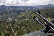
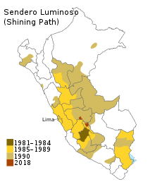
The Valle de los Ríos Apurímac, Ene y Mantaro (lit. 'Valley of the Apurímac, Ene and Mantaro rivers'), also known as the VRAEM, is a geopolitical area in Peru, located in portions of the departments of Ayacucho, Cusco, Huancavelica, and Junin.[1][2] It is one of the major areas of coca production in Peru.[3] It is also the center of operation of the far-left terrorist group Shining Path.
The area is extremely poor.[3] The VRAEM is an area of such high childhood malnutrition and poverty that the government of Peru selected the VRAEM to launch its National Strategy for Growth program in 2007.[4]
Cocaine production
[edit]Since 2012, Peru has overtaken Colombia as the world's largest cocaine-producing country.[5][6] With local incomes below $10/day, the valleys are used to produce raw paste product, and much of the drug trade is controlled by the Shining Path.[6][7] With an estimated 19,700 hectares (49,000 acres) of production area (2010), it is presently the world's densest area of cocaine production.[1][7] Paste product is shipped out of the valleys by armed native backpackers to Cuzco,[3][6] and then onward shipped to either: the Pacific Ocean ports; the Bolivian border, where it is sold to one of the drug cartels; or to mule-traffickers who ship the product onwards via scheduled air transport to Europe and North America.[6][7]
See also
[edit]References
[edit]- ^ a b "Slaves of the past". The Economist. 1 August 2015. Retrieved 3 August 2015.
- ^ "Peru Travel Advisory". travel.state.gov. Retrieved 9 May 2023.
- ^ a b c Pressly, Linda (24 November 2015). "The Mochileros". BBC News. Retrieved 24 November 2015.
- ^ "Crecer ya está en el VRAE". Comisión Interministerial de Asuntos Sociales. 21 December 2007. Retrieved 14 November 2009.
- ^ "Part 5. Peru Coca Cultivation Survey" (PDF). Peru Coca Survey for 2005. United Nations Office on Drugs and Crime. Retrieved 14 November 2009.
- ^ a b c d Archived November 25, 2015, at the Wayback Machine[dead link]
- ^ a b c Collyns, Dan (23 June 2011). "Peru's challenge to tackle cocaine trade". BBC News. Retrieved 26 November 2015.
Text is available under the CC BY-SA 4.0 license; additional terms may apply.
Images, videos and audio are available under their respective licenses.
