Uiju County
Ŭiju County
의주군 | |
|---|---|
| Korean transcription(s) | |
| • Chosŏn'gŭl | 의주군 |
| • Hancha | 義州郡 |
| • McCune-Reischauer | Ŭiju-gun |
| • Revised Romanization | Uiju-gun |
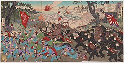
 Fierce battle at Uiju (between the Imperial Japanese army & Chinese forces, 19th C) | |
 | |
| Country | North Korea |
| Province | North P'yŏngan |
| Administrative divisions | 1 ŭp, 2 workers' districts, 17 ri |
| Area | |
| • Total | 420 km2 (160 sq mi) |
| Population (2008) | |
| • Total | 110,018 |
Ŭiju County is a kun, or county, in North Pyongan Province, North Korea. The county has an area of 420 km², and a population of 110,018 (2008 data).
Name
[edit]Ŭiju appears as Uiju in South Korea's Revised Romanization and as Yizhou in Chinese sources, as during its occupation by Mao Wenlong's forces during the Transition from Ming to Qing.
Geography
[edit]Sakchu county and Kusŏng lie to the east; Sŏnch'ŏn and Ch'ŏlsan counties to the south; and Ryongch'ŏn county and Sinŭiju to the west. To the north, Ŭiju shares a border with China.
Administrative divisions
[edit]Ŭiju county is divided into 1 ŭp (town), 2 rodongjagu (workers' districts) and 17 ri (villages):
|
|
Transportation
[edit]Ŭiju county is served by the Tŏkhyŏn Line of the Korean State Railway. There is also an airport, Uiju Airfield (ICAO airport code: ZKUJ).
1980 earthquake
[edit]Ŭiju earthquake was a 5.3 magnitude earthquake that occurred in Ŭiju County in 1980.[1] It is among the largest earthquakes by magnitude recorded in the Korean Peninsula since South Korea began official earthquake observation in 1978.[2]
See also
[edit]References
[edit]- ^ "No One Hurt as Earthquake Rocks Korea". The Chosun Ilbo. Retrieved 2015-09-09.
- ^ Kim Se-jeong (2015-04-27). "'Korea is not safe from earthquakes'". The Korea Times. Retrieved 2015-09-09.
External links
[edit]- In Korean language online encyclopedias:
| Capital | ||
|---|---|---|
| Cities | ||
| Counties | ||
Text is available under the CC BY-SA 4.0 license; additional terms may apply.
Images, videos and audio are available under their respective licenses.

