Talk:Van der Grinten projection
| This article is rated Start-class on Wikipedia's content assessment scale. It is of interest to the following WikiProjects: | |||||||||||
| |||||||||||
Replace low-contrast images
[edit]
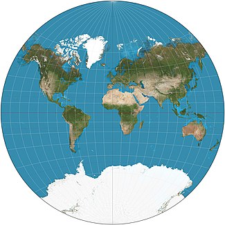
I will be replacing images on the various map projection pages. Presently many are on a satellite composite image from NASA that, while realistic, poorly demonstrates the projections because of dark color and low contrast. I have created a stylization of the same data with much brighter water areas and a light graticule to contrast. See the thumbnail of the example from another article. Some images on some pages are acceptable but differ stylistically from most articles; I will replace these also.
The images will be high resolution and antialiased, with 15° graticules for world projections, red, translucent equator, red tropics, and blue polar circles.
Please discuss agreement or objections over here (not this page). I intend to start these replacements on 13 August. Thank you. Strebe (talk) 22:48, 6 August 2011 (UTC)
Van der Grinten projection adopted like Goodwill Games emblem
[edit][[1]] Hi, the Van der Grinten projection of world map was adopted by the now-defunct Goodwill Games (1986-2001) like its emblem.Nekko09 (talk) 21:45, 4 June 2014 (UTC)
File:Van der Grinten projection SW.jpg to appear as POTD soon
[edit]Hello! This is a note to let the editors of this article know that File:Van der Grinten projection SW.jpg will be appearing as picture of the day on February 10, 2016. You can view and edit the POTD blurb at Template:POTD/2016-02-10. If this article needs any attention or maintenance, it would be preferable if that could be done before its appearance on the Main Page. — Chris Woodrich (talk) 07:13, 22 January 2016 (UTC)
- Chris Woodrich, I made a slight correction to the template; otherwise it looks good to go. Thanks! Strebe (talk) 05:30, 23 January 2016 (UTC)
Text is available under the CC BY-SA 4.0 license; additional terms may apply.
Images, videos and audio are available under their respective licenses.


