Sugar Camp, West Virginia
Sugar Camp, West Virginia | |
|---|---|
 Sugar Camp Location within the state of West Virginia  Sugar Camp Sugar Camp (the United States) | |
| Coordinates: 39°14′27″N 80°41′36″W / 39.24083°N 80.69333°W | |
| Country | |
| State | |
| County | |
| Elevation | 843 ft (257 m) |
| Time zone | UTC-5 (Eastern (EST)) |
| • Summer (DST) | UTC-4 (EDT) |
| GNIS ID | 1689595[1] |
Sugar Camp is an unincorporated community in Doddridge County, West Virginia, United States. The community is located along West Virginia Route 18 at the confluence of Toms Fork and Meathouse Fork.[2]
References
[edit]Municipalities and communities of Doddridge County, West Virginia, United States | ||
|---|---|---|
| Town | 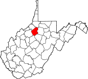 | |
| Unincorporated communities | ||
Text is available under the CC BY-SA 4.0 license; additional terms may apply.
Images, videos and audio are available under their respective licenses.
Cover photo is available under {{::mainImage.info.license.name || 'Unknown'}} license.
Cover photo is available under {{::mainImage.info.license.name || 'Unknown'}} license.
Credit:
(see original file).
