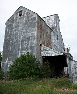
Sexton, Iowa
Sexton, Iowa | |
|---|---|
 Sexton elevator | |
| Coordinates: 43°04′58″N 94°05′21″W / 43.08278°N 94.08917°W | |
| Country | |
| State | |
| County | Kossuth |
| Townships | Irvington, Prairie |
| Post office opened | August 20, 1888 |
| Area | |
| • Total | 2.20 sq mi (5.70 km2) |
| • Land | 2.20 sq mi (5.70 km2) |
| • Water | 0.00 sq mi (0.00 km2) |
| Elevation | 1,220 ft (370 m) |
| Population (2020) | |
| • Total | 46 |
| • Density | 20.89/sq mi (8.07/km2) |
| Time zone | UTC-6 (Central (CST)) |
| • Summer (DST) | UTC-5 (CDT) |
| ZIP Code | 50483 |
| Area code | 515 |
| GNIS feature ID | 461516[2] |
| FIPS code | 19-71715 |
Sexton is an unincorporated community and census-designated place in Irvington Township, Kossuth County, Iowa, United States. It is located at the intersection of U.S. Route 18 and Kossuth CR P60. As of the 2010 census it had a population of 37.[3]
History
[edit]Sexton was platted in 1889.[4] Sexton's population was 42 in 1902.[5]
The town contained a post office from August 1888 until May 1974.[6]
A few houses, a Racer's Bar and Grill and the Sexton elevator remain.
Geography
[edit]Sexton is in southeastern Kossuth County, 8 miles (13 km) east of Algona, the county seat, and 5 miles (8 km) west of Wesley. According to the U.S. Census Bureau, the Sexton CDP has an area of 2.2 square miles (5.7 km2), all land.[3] The CDP is on the south side of U.S. Route 18.
Demographics
[edit]| Census | Pop. | Note | %± |
|---|---|---|---|
| 2020 | 46 | — | |
| U.S. Decennial Census[7] | |||
References
[edit]- ^ "2020 U.S. Gazetteer Files". United States Census Bureau. Retrieved March 16, 2022.
- ^ "Feature Detail Report for: Sexton." USGS. URL Retrieved June 26, 2010.
- ^ a b "Geographic Identifiers: 2010 Demographic Profile Data (G001): Sexton CDP, Iowa". American Factfinder. U.S. Census Bureau. Retrieved February 28, 2019.[dead link]
- ^ Reed, Benjamin F. (1913). History of Kossuth County, Iowa, Volume 1. S. J. Clarke Publishing Company. p. 589.
- ^ Cram's Modern Atlas: The New Unrivaled New Census Edition. J. R. Gray & Company. 1902. pp. 203–207.
- ^ "Feature Detail Report for: Sexton Post Office (historical)." USGS. URL Retrieved June 26, 2010.
- ^ "Census of Population and Housing". Census.gov. Retrieved June 4, 2016.
Municipalities and communities of Kossuth County, Iowa, United States | ||
|---|---|---|
| Cities | ||
| Townships | ||
| CDPs | ||
| Unincorporated communities | ||
| Ghost town | ||
| Footnotes | ‡This populated place also has portions in an adjacent county or counties | |
Text is available under the CC BY-SA 4.0 license; additional terms may apply.
Images, videos and audio are available under their respective licenses.


