Savannakhet
Savannakhet
ເມືອງໄກສອນ ພົມວິຫານ | |
|---|---|
District and municipality | |
| Kaysone Phomvihane District | |
 The commercial centre of Kaysone Phomvihane, Savannakhet Province | |
 Savannakhet | |
| Coordinates: 16°33′N 104°45′E / 16.550°N 104.750°E | |
| Country | |
| Province | Savannakhet Province |
| Population (2018) | |
| • Total | 125,760 |
| Time zone | UTC+7 (ICT) |
Savannakhet (Lao: ສະຫວັນນະເຂດ, pronounced [sā.wǎn nā(ʔ).kʰȅːt]), officially named Kaysone Phomvihane (Lao: ໄກສອນ ພົມວິຫານ); since 2005 and previously known as Khanthaboury (Lao: ຄັນທະບູລີ), is a city in western Laos. It is the capital of Savannakhet Province. With a population of 125,760 (2018),[1] it is the second-largest city in Laos, after Vientiane. Although the old French colonial quarter of the town, along the Mekong River-front, is depressed and crumbling, the town's proximity to Thailand's booming economy has brought about new commercial development in the northern part of the town, near both the river crossing and the bus terminal.
Like all Lao cities, Savannakhet has a mixed population of Lao, Thai, Vietnamese and Chinese, as well as minority peoples from the Lao interior. It has a large 15th-century Buddhist temple, Wat Sainyaphum, a Chinese temple, the Catholic Co-Cathedral of St. Therese and a mosque. The Second Thai–Lao Friendship Bridge over the Mekong connects to Mukdahan Province in Thailand. The two-lane, 12-metre-wide (39 ft), 1,600-metre-long (5,250 ft) bridge opened to the general public on 9 January 2007.
The annual per capita income of Kaysone Phomvihane City is US$2,041 (2018).[1]
Name change
[edit]The settlement of Savannakhet was formerly called Khanthaboury. Then it became Savannakhet. Its name was changed to Kaysone Phomvihane in 2005, while retaining its status as the provincial capital of Savannakhet Province. The city is the birthplace of Kaysone Phomvihane, the first leader of Laos from 1975 to 1992 after the dissolution of the Kingdom of Laos. In 2018, its status was upgraded to that of a "city". In order to attain city status, a district or municipality must be financially self-sufficient and have a population of at least 60,000 persons.[1]
Transport
[edit]The city is served by Savannakhet Airport.
Climate
[edit]Savannakhet features a tropical savanna climate (Aw) according to Köppen climate classification with a little subtropical climate characteristics as the city located 16.5° north of the equator. The hottest month is April (mean = 29.5 °C (85.1 °F)) with temperature ranging from 23.9 °C (75.0 °F) to 35.2 °C (95.4 °F), while the coolest month is December (mean = 21.7 °C (71.1 °F)) with temperature ranging from 15.2 °C (59.4 °F) to 28.7 °C (83.7 °F). The diurnal temperature variation seems to be greater during winter due to dry conditions. The city experiences dry season during winter months and wet season during summer months due to activation of monsoon. The driest month is December with precipitation total 2.0 millimetres (0.079 in), while the wettest month is August with precipitation total 323.1 millimetres (12.72 in).
| Climate data for Savannakhet (1991-2020) | |||||||||||||
|---|---|---|---|---|---|---|---|---|---|---|---|---|---|
| Month | Jan | Feb | Mar | Apr | May | Jun | Jul | Aug | Sep | Oct | Nov | Dec | Year |
| Record high °C (°F) | 38.5 (101.3) |
39.5 (103.1) |
42.0 (107.6) |
41.5 (106.7) |
41.2 (106.2) |
38.0 (100.4) |
38.5 (101.3) |
36.3 (97.3) |
36.3 (97.3) |
36.0 (96.8) |
36.5 (97.7) |
38.0 (100.4) |
42.0 (107.6) |
| Mean daily maximum °C (°F) | 29.7 (85.5) |
31.8 (89.2) |
34.2 (93.6) |
35.1 (95.2) |
33.9 (93.0) |
32.5 (90.5) |
31.2 (88.2) |
30.9 (87.6) |
31.4 (88.5) |
31.1 (88.0) |
31.2 (88.2) |
28.6 (83.5) |
31.7 (89.1) |
| Daily mean °C (°F) | 22.2 (72.0) |
24.4 (75.9) |
27.4 (81.3) |
29.0 (84.2) |
28.8 (83.8) |
28.4 (83.1) |
27.4 (81.3) |
27.2 (81.0) |
27.3 (81.1) |
26.1 (79.0) |
24.3 (75.7) |
21.9 (71.4) |
26.2 (79.2) |
| Mean daily minimum °C (°F) | 15.8 (60.4) |
17.9 (64.2) |
21.7 (71.1) |
24.1 (75.4) |
25.0 (77.0) |
25.3 (77.5) |
24.6 (76.3) |
24.5 (76.1) |
24.2 (75.6) |
22.0 (71.6) |
19.2 (66.6) |
16.2 (61.2) |
21.7 (71.1) |
| Record low °C (°F) | 5.8 (42.4) |
9.0 (48.2) |
10.0 (50.0) |
15.0 (59.0) |
17.5 (63.5) |
19.0 (66.2) |
18.2 (64.8) |
18.0 (64.4) |
18.0 (64.4) |
12.0 (53.6) |
8.5 (47.3) |
7.0 (44.6) |
5.8 (42.4) |
| Average precipitation mm (inches) | 3.3 (0.13) |
19.3 (0.76) |
40.6 (1.60) |
69.3 (2.73) |
206.2 (8.12) |
216.5 (8.52) |
307.1 (12.09) |
333.9 (13.15) |
239.3 (9.42) |
74.2 (2.92) |
7.3 (0.29) |
4.0 (0.16) |
1,521 (59.88) |
| Average precipitation days (≥ 1.0 mm) | 1 | 2 | 4 | 6 | 13 | 14 | 18 | 19 | 15 | 7 | 2 | 1 | 100 |
| Average relative humidity (%) | 69 | 68 | 65 | 67 | 75 | 78 | 80 | 83 | 81 | 76 | 72 | 70 | 73.7 |
| Mean monthly sunshine hours | 246.8 | 222.4 | 225.6 | 217.4 | 191.2 | 165.0 | 142.1 | 115.9 | 154.6 | 202.8 | 225.3 | 236.9 | 2,345.9 |
| Source 1: NOAA (humidity, 1961-1990 and extremes)[2][3][4] | |||||||||||||
| Source 2: The Yearbook of Indochina (1932-1933)[5] | |||||||||||||
-
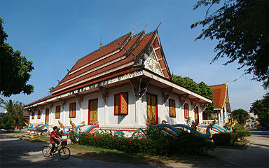 Wat Sainyaphum
 -
 Chinese Buddhist Temple
 -
 Vietnamese Buddhist Temple Diệu Giác
 -
 St. Teresa's Catholic Church


Sister cities
[edit]References
[edit]- ^ a b c Yap, Jasmina (28 May 2018). "Town of Kaysone Phomvihane Officially Declared a City". The Laotian Times. Retrieved 30 May 2020.
- ^ "World Meteorological Organization Climate Normals for 1991-2020 — Savannakhet". National Oceanic and Atmospheric Administration. Retrieved 17 January 2024.
- ^ "Savannakhet Climate Normals 1961–1990". National Oceanic and Atmospheric Administration. Archived from the original on 17 July 2020. Retrieved 29 November 2013.
- ^ "Global Surface Summary of the Day - GSOD". National Oceanic and Atmospheric Administration. Retrieved 26 January 2023.
- ^ The Yearbook of Indochina (1932-1933)
External links
[edit] Savannakhet travel guide from Wikivoyage
Districts of Southern Laos | |
|---|---|
| Attapeu province | |
| Champasak province | |
| Khammouane province | |
| Salavan province | |
| Savannakhet province | |
| Sekong province | |
※ denotes provincial seat. | |
| International | |
|---|---|
| National | |
| Other | |
Text is available under the CC BY-SA 4.0 license; additional terms may apply.
Images, videos and audio are available under their respective licenses.
