Ranton, Staffordshire
| Ranton | |
|---|---|
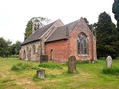
 All Saints Church, Ranton | |
Location within Staffordshire | |
| Population | 382 (2011 Census) |
| District | |
| Shire county | |
| Region | |
| Country | England |
| Sovereign state | United Kingdom |
| Post town | Stafford |
| Postcode district | ST18 |
| Police | Staffordshire |
| Fire | Staffordshire |
| Ambulance | West Midlands |
| UK Parliament | |
Ranton is a small hamlet in Staffordshire, England, situated 3.5 miles (5.6 km) west of Stafford, 2.5 miles (4.0 km) east of Woodseaves and 2 miles (3.2 km) northeast of Gnosall. The population taken at the 2011 census was 382.[1] As of 2013, both public houses that once operated in Ranton were bought and subsequently removed from operation. Due to this, Ranton is now listed as a hamlet.
History
[edit]Ranton is listed under the Pirehill Hundred section of Domesday Book. There is debate as to how the name Ranton was spelt prior to the 18th century, possibilities include 'Ronton', 'Rantone' (as named in Domesday Book in 1086[2]) and 'Rantun' (rarely used).
All Saints church, Ranton
[edit]All Saints church, Ranton, is a small ancient structure, dating from the 13th century.
The building was renovated in 1753, when the chancel was built. The east window was probably put in at this time. The bell turret was removed in 1889, but was re-erected in the 1940s in memory of Frank Russell and John Owen Timms, two local men who lost their lives in the Second World War. The new turret was not strong enough to support the bells, which had to be removed and put onto storage until the turret was rebuilt.[3] The church has a small bell-tower at the west end of the nave with two bells, and was repaired and a gallery erected in 1840. The restoration was supervised by Staffordshire ecclesiastical architect Andrew Capper.[4] The parish registers commence in 1655. The original registers for the period 1655-1993 (Baptisms), 1655-1984 (Marriages) & 1655-1993 (Burials) are deposited at Staffordshire Record Office. Bishops Transcripts, 1660-1868 (with gaps 1840–1854) are deposited at Lichfield Record office.[5]
The ruins of both Ranton Abbey and Abbey House stand nearby.
See also
[edit]References
[edit]- ^ "Civil Parish population 2011". Retrieved 11 December 2015.
- ^ "Bad Credit Loans Online | High Acceptance Rates | Quick Loans Express".
- ^ All Saint's Church, Ranton
- ^ All Saints, Ranton
- ^ Ranton
External links
[edit]Text is available under the CC BY-SA 4.0 license; additional terms may apply.
Images, videos and audio are available under their respective licenses.

