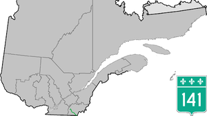
Quebec Route 141
 | ||||
| Route information | ||||
| Maintained by Transports Québec | ||||
| Length | 80.8 km[1] (50.2 mi) | |||
| Major junctions | ||||
| South end | ||||
| North end | ||||
| Location | ||||
| Country | Canada | |||
| Province | Quebec | |||
| Highway system | ||||
| ||||

Route 141 is a north/south highway in Quebec on the south shore of the Saint Lawrence River. Its northern terminus is in Magog at the junction of Route 112 and Autoroute 10, and the southern terminus is in Saint-Herménégilde at the United States border in Canaan, Vermont.
Municipalities along Route 141
[edit]- Saint-Herménégilde
- Dixville
- Coaticook
- Barnston-Ouest
- Stanstead-Est
- Ayer's Cliff
- Sainte-Catherine-de-Hatley
- Magog
- Orford
Major intersections
[edit]| RCM or ET | Municipality | Km | Junction | Notes |
|---|---|---|---|---|
Southern terminus of Route 141
| ||||
| Coaticook | Saint-Herménégilde | 0.0 | 141 SOUTH: to Canaan, Vermont and | |
| 17.7 | 251 NORTH: to Sainte-Edwidge-de-Clifton | |||
| Coaticook | 26.0 | 147 SOUTH: to Dixville | ||
| 27.9 | 206 EAST: to Sainte-Edwidge-de-Clifton | |||
| 28.4 | 147 NORTH: to Compton | |||
| Memphrémagog | Stanstead-East | 47.9 | 143 SOUTH: to Stanstead 143 NORTH: to Hatley | |
| Ayer's Cliff | 50.4 | 208 EAST: to Hatley | ||
| Sainte-Catherine-de-Hatley | 54.1 54.3 |
55 NORTH: to Magog 55 SOUTH: to Stanstead-Est | ||
| Magog | 66.7 | 247 SOUTH: to Stanstead Township | ||
| 67.0(*) | 112 WEST: to Austin 112 EAST: to Sherbrooke | |||
| 70.2 70.5 |
10 EAST: to Sherbrooke 10 WEST: to Austin | |||
| 80.8 | 112 WEST: to Austin 112 EAST: to Sherbrooke | |||
Northern terminus of Route 141
| ||||
See also
[edit]References
[edit]- ^ Ministère des transports, "Distances routières", page 69, Les Publications du Québec, 2005
External links
[edit]- Provincial Route Map (Courtesy of the Quebec Ministry of Transportation) (in French)
- Route 141 on Google Maps
Text is available under the CC BY-SA 4.0 license; additional terms may apply.
Images, videos and audio are available under their respective licenses.

